Approximate Location Map
Large Map »
Latitude: 51.2822 / 51°16'55"N
Longitude: 1.0803 / 1°4'49"E
OS Eastings: 614908
OS Northings: 158177
OS Grid: TR149581
Mapcode National: GBR TY2.HYF
Mapcode Global: VHLGM.N1ZD
Plus Code: 9F3373JJ+V4
Entry Name: 4 and 5, Mill Lane
Listing Date: 3 May 1967
Grade: II
Source: Historic England
Source ID: 1096930
English Heritage Legacy ID: 439782
ID on this website: 101096930
Location: Canterbury, Kent, CT1
County: Kent
District: Canterbury
Electoral Ward/Division: Westgate
Parish: Non Civil Parish
Built-Up Area: Canterbury
Traditional County: Kent
Lieutenancy Area (Ceremonial County): Kent
Tagged with: Building
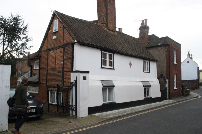
1.
944 MILL LANE
(East Side)
Nos 4 & 5
TR 1458 SE 2/296 3.5.67.
II GV
2.
Early C17 timber-framed building now plastered over on front elevation. 2 storeys.
Restored tiled roof with 1 massive restored brick chimney. 2 casements. The
left side has exposed timber-framing with modern brick infill, Modern extension
to rear.
Nos 2 to 12 (consec) form a group.
Listing NGR: TR1362657999
External links are from the relevant listing authority and, where applicable, Wikidata. Wikidata IDs may be related buildings as well as this specific building. If you want to add or update a link, you will need to do so by editing the Wikidata entry.


Other nearby listed buildings
