Approximate Location Map
Large Map »
Latitude: 52.0097 / 52°0'34"N
Longitude: -2.7494 / 2°44'57"W
OS Eastings: 348662
OS Northings: 234852
OS Grid: SO486348
Mapcode National: GBR FJ.HJNN
Mapcode Global: VH85V.9RC6
Plus Code: 9C4V2752+V7
Entry Name: Two Gate Piers, Gate, Wall and Mounting Block About 25 Yards North of Haywood Farmhouse
Listing Date: 22 October 1986
Last Amended: 2 April 1987
Grade: II
Source: Historic England
Source ID: 1099672
English Heritage Legacy ID: 155373
ID on this website: 101099672
Location: Callow, County of Herefordshire, HR2
County: County of Herefordshire
Civil Parish: Haywood
Traditional County: Herefordshire
Lieutenancy Area (Ceremonial County): Herefordshire
Church of England Parish: Dewsall with Callow
Church of England Diocese: Hereford
Tagged with: Building
The entry for:
HAYWOOD CP
SO 43 SE
6/73 Four Gate piers, gate, wall and
mounting block about 25 yards north
of Haywood Farmhouse
II
Should be amended to read:
SO 43 SE HAYWOOD CP
6/73 Two gate piers, gate, wall and
mounting block about 25 yards north
of Haywood Farmhouse
II
The description to read:
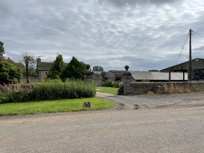
Gate piers, gate, wall and mounting block. C18. Sandstone ashlar, squared
sandstone and wrought iron with brick mounting block. Wall is aligned east/west
and extends about 15 yards between piers which are about 7 feet high with moulded
bases and cornices above which are ball finials. To the right of the gate is a
brick mounting block with four stone steps. Haywood Farmhouse is not included in
this list. The previous Haywood Farmhouse was demolished c1984. (BoE, p 143; RCHM,
Vol I, p 84).
------------------------------------
HAYWOOD CP -
SO 43 SE
6/73
Four gate piers, gate,
wall and mounting block
about 25 yards north of
Haywood Farmhouse
- II
Gate piers, gate, wall and mounting block. C18. Sandstone ashlar, squared
sandstone and wrought iron with brick mounting block. Wall is aligned
east/west and extends about 15 yards between outer piers which are about
11 feet high with moulded bases and cornices above which are ball finials.
Inner pyramidically capped piers are lower and linked to the outer pair by
a stretch of wall. Between the inner pair is a gate with spear-headed bars
and loops. To the right of the gate is a brick mounting block with four
stone steps. Haywood Farmhouse is not included in this list. The previous
Haywood Farmhouse was demolished c1984. (BoE, p 143; RCHM, Vol I, p 84).
Listing NGR: SO4866234852
External links are from the relevant listing authority and, where applicable, Wikidata. Wikidata IDs may be related buildings as well as this specific building. If you want to add or update a link, you will need to do so by editing the Wikidata entry.


Other nearby listed buildings
