Approximate Location Map
Large Map »
Latitude: 53.6492 / 53°38'57"N
Longitude: -0.2196 / 0°13'10"W
OS Eastings: 517778
OS Northings: 418443
OS Grid: TA177184
Mapcode National: GBR VVX7.8L
Mapcode Global: WHHHB.LJNS
Plus Code: 9C5XJQXJ+M5
Entry Name: Killingholme North Low Lighthouse
Listing Date: 17 October 1985
Grade: II
Source: Historic England
Source ID: 1103707
English Heritage Legacy ID: 165872
Also known as: Killingholme North Low Light
ID on this website: 101103707
Location: North Lincolnshire, DN40
County: North Lincolnshire
Civil Parish: South Killingholme
Traditional County: Lincolnshire
Lieutenancy Area (Ceremonial County): Lincolnshire
Church of England Parish: North and South Killingholme St Denys
Church of England Diocese: Lincoln
Tagged with: Lighthouse
TA 11 NE SOUTH KILLINGHOLME
TA 177 184
11/72 Killingholme North Low
Lighthouse
GV II
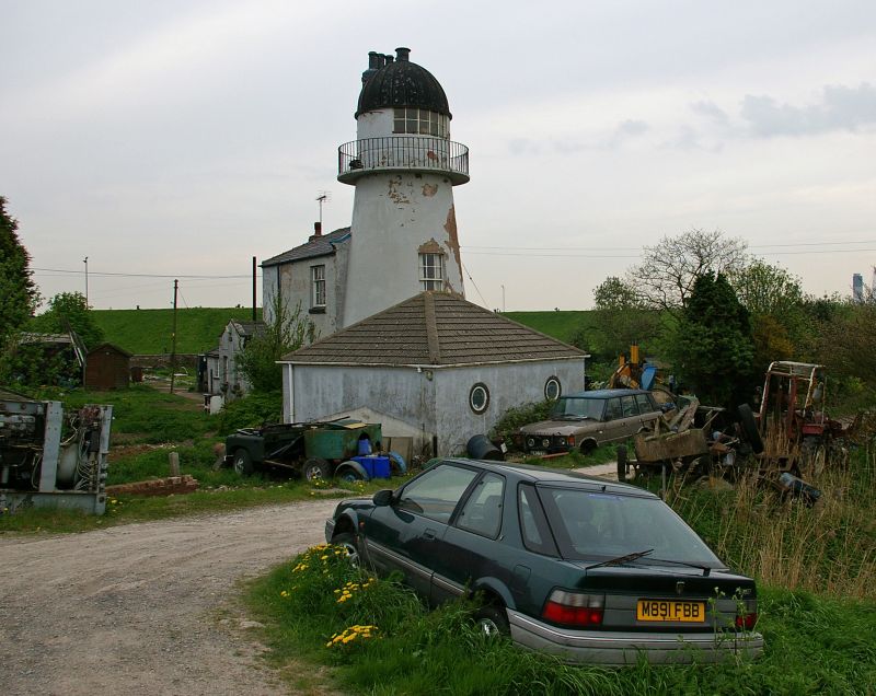
Lighthouse and adjoining lighthouse keeper's house, now house. 1851 by
William Foale for Trinity House, with later alterations and additions to
rear. Brick, smooth-rendered to lighthouse, rough-rendered to house. Slate
roof to house. Front to seaward. 4-storey tapered round tower with 2-
storey 2-bay house adjoining to left (south); single-storey extensions to
left and rear. Tower: prominently splayed-out base, recessed bowed 12-pane
sashes with projecting cills to first three floors. Top floor has balcony
with plain iron railings, plinth, incised chamfered band, recessed panelled
door, small casement and wide 10-pane north-facing window. Ribbed dome with
scalloped eaves. Projecting stack corbelled out at top of tower, with 4
octagonal pots. House: projecting enclosed gabled porch to left with C20
door to right side, two 4-pane sashes to front with projecting cills and
recessed cambered arches and coped gable with shaped kneelers. Single
unequal sash with glazing bars to first floor right. Coped gable with
shaped kneelers abutting lighthouse tower to right; hipped roof to left with
end stack. Extensions to left in similar materials, with C20 casements and
hipped roofs. The lighthouse was used as a signal station for trawlers
until 1920. Date of erection and names of wardens recorded on plaque on
nearby Killingholme High Lighthouse (q.v.). D. Jackson, Lighthouses of
England and Wales, 1975, 104-5; D B Hague & R Christie, Lighthouses, 1975,
218.
Listing NGR: TA1777818443
External links are from the relevant listing authority and, where applicable, Wikidata. Wikidata IDs may be related buildings as well as this specific building. If you want to add or update a link, you will need to do so by editing the Wikidata entry.


Other nearby listed buildings
