Approximate Location Map
Large Map »
Latitude: 50.7939 / 50°47'38"N
Longitude: -1.106 / 1°6'21"W
OS Eastings: 463103
OS Northings: 99751
OS Grid: SZ631997
Mapcode National: GBR VNN.DN
Mapcode Global: FRA 86KZ.YQH
Plus Code: 9C2WQVVV+HH
Entry Name: Vulcan Block (Building Number 21) and Attached Bollards
Listing Date: 25 September 1972
Last Amended: 13 August 1999
Grade: II
Source: Historic England
Source ID: 1104329
English Heritage Legacy ID: 474696
ID on this website: 101104329
Location: Old Portsmouth, Portsmouth, Hampshire, PO1
County: City of Portsmouth
Electoral Ward/Division: St Thomas
Parish: Non Civil Parish
Built-Up Area: Portsmouth
Traditional County: Hampshire
Lieutenancy Area (Ceremonial County): Hampshire
Church of England Parish: St Thomas of Canterbury, Portsmouth
Church of England Diocese: Portsmouth
Tagged with: Building
SZ 6399 PORTSMOUTH GUNWHARF ROAD
(West side}
774-1/12/22
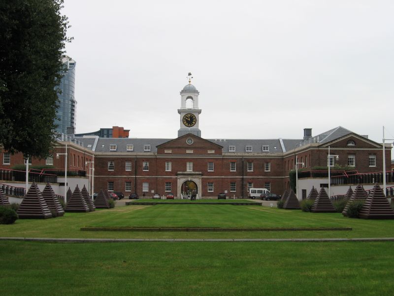
HMS Vernon Vulcan Block
25.09.1972 (Building No. 21) and
attached bollards
GV II
Ordnance storehouse with stabling; disused. 1811-14 (dated 1814}, later alterations, almost certainly by Major-General Evelegh, for the Ordnance Board. Patterned red brick with grey headers in Flemish bond with Portland dressings and gauged red brick arches to openings. Hipped slate roof with flat roofed dormers (boarded up). Late Georgian style.
PLAN: large symmetrical U-block plan with spine walls, the north wing demolished after c1940 wartime bomb damage.
EXTERIOR: 2 storeys with attic. 12-bay east principal elevation with 11-bay south wing to rear. Tooled ashlar plinth and plat band, rendered stepped dentilled eaves below ashlar course and rendered brick blocking course. Windows have 8/8-pane sashes in reveals, stone sills and flat arches. Large entrances have double boarded doors in stepped round-arched surrounds flanked by bollards formed by disused cannon barrels set on end (probably early-mid C19, set in present position mid-late C19).
East elevation: originally symmetrical1 5 bays, the 3 right hand bays (end of former north wing) now gone. 5-bay centre 1:3:1 breaks forward twice, has grand entrance to archway into rear courtyard in ashlar architrave with rusticated spandrels and outer Tuscan architrave. At left, end of wing forms 3-bay, pedimented shallow projection with lunette in tympanum. Main entrance has plaque above (inscribed 'Major-General Fisher, Commanding Royal Engineers 1814') and leads into a wide through-passage, off which are wide round-arched entrances with double doors and a trap-door in the ceiling set above a girder with running pulley. The west (courtyard) elevation is the same, including,the grand entrance (now blocked).
South wing symmetrical; bays arranged 1:3:3:3:1, the centre piece projecting below pediment with a lunette in tympanum, and round-arched doorway in matching recess to double doors; the end bays narrow, projecting, and having a round-arched recess filled with grey headers on each floor. The west elevation is 3 bays below pediment, central entrance and lunette in tympanum. At south-east corner of building is cannon barrel bollard.
INTERIOR: ground-floor storage bays flanking axial spine walls it1$erted in two phases between 1892 and 1893; tall cast-iron columns with cast mid supports to inner shelf, eyes for attaching divisions, and spreaders to large scantling first-floor wooden beams; axial line of first-floor posts supporting cross beams; wide-span roof, with iron strapping to a post-and-pad form surmounted by king posts. Cast-iron fire doors with panels between separate sections; stick-baluster stair at angle between wings.
HISTORY: armaments and Ordnance stores were kept here while ships were in Ordinary at Portsmouth dockyard. The old Gun Wharf Yard was extended to New Gun Wharf in the 1770s, of which this forms the centrepiece. As such it is part of the very significant historic dockyard complex. It was also, at its completion, one of the largest storehouses owned by the Board of Ordnance after that at Chatham. This patterned brick work is found at other local Ordnance Board buildings of the time such as Priddy's Hard and Milldam Barracks (qqv).
(Sources: Coad JG: The Royal Dockyards 1690-1850: Aldershot: 1989: 258 ; Coad J: Historic Architecture of HM Naval Base Portsmouth 1700-1850: Portsmouth: 1981: 54; PSA drawings in National Monuments Record, Swindon, cover 1890s phase).
Listing NGR: SU6610802158
External links are from the relevant listing authority and, where applicable, Wikidata. Wikidata IDs may be related buildings as well as this specific building. If you want to add or update a link, you will need to do so by editing the Wikidata entry.


Other nearby listed buildings
