Approximate Location Map
Large Map »
Latitude: 50.7175 / 50°43'3"N
Longitude: -1.8726 / 1°52'21"W
OS Eastings: 409090
OS Northings: 90887
OS Grid: SZ090908
Mapcode National: GBR X80.FX
Mapcode Global: FRA 67Z5.SBV
Plus Code: 9C2WP49G+2X
Entry Name: Royal Bath Hotel
Listing Date: 1 August 1974
Grade: II
Source: Historic England
Source ID: 1108883
English Heritage Legacy ID: 101705
Also known as: Bath hotel
ID on this website: 101108883
Location: Bournemouth, Bournemouth, Christchurch and Poole, Dorset, BH1
County: Bournemouth, Christchurch and Poole
Parish: Non Civil Parish
Built-Up Area: Bournemouth
Traditional County: Hampshire
Lieutenancy Area (Ceremonial County): Dorset
Church of England Parish: Bournemouth Town Centre
Church of England Diocese: Winchester
Tagged with: Hotel
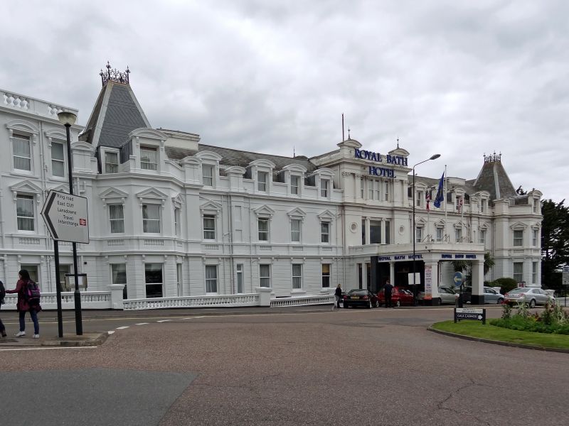
1. BATH ROAD
5l86 (East Side)
Royal Bath Hotel
SZ 099O 19/168 1.8.74.
II
2.
1837-8, Benjamin Ferrey for Sir George Tapps-Gervis, vastly extended 1878-80
by C C Creeke for hotelier Sir Merton Russell-Cotes. Stucco classical, 2 and
3 storeys, varied silhouette. Ferrey's hotel survives in main entrance wing
at south end: composition of centre and wings is his, with tripartite 1st floor
window framed by Ionic columns. Creeke added 2nd floor to centre, with Corinthian
columns, also projecting corner pavilions with canted bays and recessed chateau
roofs of patterned slate (iron cresting). Garden side also symmetrical with
central bow under conical roof, conservatory across front. To north, street
front has facade, 5 windows wide, in Barry-Italianate: rusticated ground floor,
triangular pediments to lst floor windows, segmental pediments to 2nd floor windows,
balustraded parapet. Beyond it, Buttery entrance under narrow segmental pediment
between canted bays, followed by long 2-storey Casino Club, with 3 spired tourelles,
patterned slates, moulded corbel- bases. On garden side big later extension with
another conical-roofed bow between polygonal towers with short spires. Recent
block to north-east. For Russell-Cotes Museum, see Russell-Cotes Road.
Listing NGR: SZ0909090887
External links are from the relevant listing authority and, where applicable, Wikidata. Wikidata IDs may be related buildings as well as this specific building. If you want to add or update a link, you will need to do so by editing the Wikidata entry.


Other nearby listed buildings
