Approximate Location Map
Large Map »
Latitude: 53.0168 / 53°1'0"N
Longitude: -1.733 / 1°43'58"W
OS Eastings: 418006
OS Northings: 346645
OS Grid: SK180466
Mapcode National: GBR 48Q.ST0
Mapcode Global: WHCF5.BFZL
Plus Code: 9C5W2788+PQ
Entry Name: 12, Dig Street
Listing Date: 14 February 1974
Grade: II
Source: Historic England
Source ID: 1109515
English Heritage Legacy ID: 79857
ID on this website: 101109515
Location: Ashbourne, Derbyshire Dales, Derbyshire, DE6
County: Derbyshire
District: Derbyshire Dales
Civil Parish: Ashbourne
Built-Up Area: Ashbourne
Traditional County: Derbyshire
Lieutenancy Area (Ceremonial County): Derbyshire
Church of England Parish: Ashbourne St Oswald
Church of England Diocese: Derby
Tagged with: Building
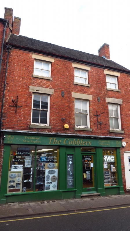
DIG STREET
1.
783
(North-East Side)
No 12
SK 14 NE 1/61E
II GV
2.
Late C18/early C19. Red brick, slate roof. 3 storeys, 3 windows, sashes without
glazing bars. 1st floor with keystones, lintels, and centre blank. Modern shop
front.
Nos 2 to 14 (even) form a group.
Listing NGR: SK1801246644
External links are from the relevant listing authority and, where applicable, Wikidata. Wikidata IDs may be related buildings as well as this specific building. If you want to add or update a link, you will need to do so by editing the Wikidata entry.


Other nearby listed buildings
