Approximate Location Map
Large Map »
Latitude: 53.0167 / 53°1'0"N
Longitude: -1.7333 / 1°43'59"W
OS Eastings: 417990
OS Northings: 346632
OS Grid: SK179466
Mapcode National: GBR 48Q.SQH
Mapcode Global: WHCF5.BFWP
Plus Code: 9C5W2788+MM
Entry Name: 9, Dig Street
Listing Date: 14 February 1974
Grade: II
Source: Historic England
Source ID: 1109516
English Heritage Legacy ID: 79859
ID on this website: 101109516
Location: Ashbourne, Derbyshire Dales, Derbyshire, DE6
County: Derbyshire
District: Derbyshire Dales
Civil Parish: Ashbourne
Built-Up Area: Ashbourne
Traditional County: Derbyshire
Lieutenancy Area (Ceremonial County): Derbyshire
Church of England Parish: Ashbourne St Oswald
Church of England Diocese: Derby
Tagged with: Building
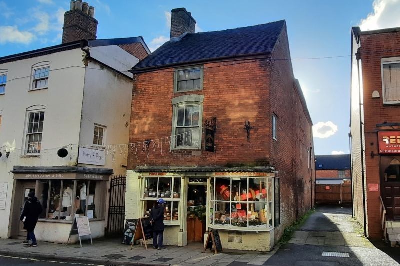
DIG STREET
1.
783
(South-West Side)
No 9
SK 14 NE 1/62 6.5.70.
II GV
2.
C18. Red brick, tiled roof. 3 storeys, one window. Contemporary small double
shop front.
Nos 9 to 17 (odd) form a group.
Listing NGR: SK1799046632
External links are from the relevant listing authority and, where applicable, Wikidata. Wikidata IDs may be related buildings as well as this specific building. If you want to add or update a link, you will need to do so by editing the Wikidata entry.


Other nearby listed buildings
