Approximate Location Map
Large Map »
Latitude: 53.3311 / 53°19'51"N
Longitude: -1.6533 / 1°39'11"W
OS Eastings: 423186
OS Northings: 381628
OS Grid: SK231816
Mapcode National: GBR JYWX.VM
Mapcode Global: WHCCN.KJXP
Plus Code: 9C5W88JW+CM
Entry Name: Hall Farmhouse, Boundary Wall and Gate Piers
Listing Date: 19 February 1985
Grade: II
Source: Historic England
Source ID: 1109796
English Heritage Legacy ID: 81172
ID on this website: 101109796
Location: Hathersage, Derbyshire Dales, Derbyshire, S32
County: Derbyshire
District: Derbyshire Dales
Civil Parish: Hathersage
Built-Up Area: Hathersage
Traditional County: Derbyshire
Lieutenancy Area (Ceremonial County): Derbyshire
Church of England Parish: Hathersage St Michael and All Angels
Church of England Diocese: Derby
Tagged with: Building
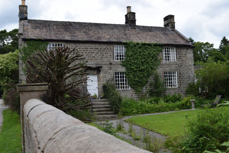
SK 23 81 PARISH OF HATHERSAGE BAULK LANE
6/10 (East Side)
Hall Farmhouse, boundary
wall and gate piers
GV II
Farmhouse. Late C18. Coursed squared gritstone with quoins, coped gables,
plain kneelers, intermediate and end ashlar ridge stacks and slate roof laid
to diminishing courses. Two storeys, three bays, with small paned cast iron
frames within flush stone surrounds. Off-centre doorway with quoined surround,
heavy lintel and shallow moulded hood on moulded brackets. Garden wall to south
west boundary with half round copings, incorporating ashlar gate piers, square
in plan, with plain caps. Semi-circular arched head to doorway, with plain
planked door.
Listing NGR: SK2318681628
External links are from the relevant listing authority and, where applicable, Wikidata. Wikidata IDs may be related buildings as well as this specific building. If you want to add or update a link, you will need to do so by editing the Wikidata entry.


Other nearby listed buildings
