Approximate Location Map
Large Map »
Latitude: 50.9211 / 50°55'15"N
Longitude: -2.3079 / 2°18'28"W
OS Eastings: 378452
OS Northings: 113557
OS Grid: ST784135
Mapcode National: GBR 0X5.5BW
Mapcode Global: FRA 661N.YGW
Plus Code: 9C2VWMCR+CR
Entry Name: Town Bridge
Listing Date: 4 October 1960
Last Amended: 3 July 2015
Grade: I
Source: Historic England
Source ID: 1110531
English Heritage Legacy ID: 102404
Also known as: Sturminster Newton Bridge
ID on this website: 101110531
Location: Newton, Dorset, DT10
County: Dorset
Civil Parish: Sturminster Newton
Traditional County: Dorset
Lieutenancy Area (Ceremonial County): Dorset
Church of England Parish: Sturminster Newton St Mary
Church of England Diocese: Salisbury
Tagged with: Road bridge
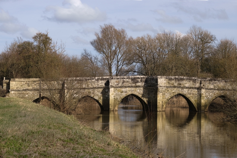
A multi-span bridge, dating from the late C15 or early C16; widened in the C17.
A multi-span bridge, dating from the late C15 or early C16; widened in the C17.
MATERIALS
The bridge is constructed of ashlar and squared rubble stone.
DESCRIPTION
The bridge, which has six two-centred arches, carries a road 18ft (approx. 4m) wide across the River Stour. The arches to the earlier, 12ft-wide bridge, which are visible to both sides, are slightly gradated, have chamfered ashlar archivolts ending in run-out stops at springing level. The C17 aches are segmental-pointed and spring from corbelled string courses inserted above the cutwaters of the original piers. Between each pair of arches the points of the cutwaters extend upwards to road level. The larger, central cutwaters are corbelled out at the top to form pedestrian refuges to either side of the road. The level of the roadway is marked to both sides by hollow-chamfered string courses, much weathered, above which are squared parapets with coping, a single row to the road side, and in two stages to the river side. The central upstream cutwater has a datestone for 1820, which is upside down when viewed from alongside the bridge, but appears correctly when viewed from the roadway on the bridge. The most northerly cutwater on the same side carries a datestone for 1827. The entrances to the bridge have splayed parapets. Town Bridge is one of a number of bridges in the county to have an iron plaque affixed, in this case within the downstream refuge, which carries the text ‘ANY PERSON WILFULLY INJURING ANY PART OF THIS COUNTY BRIDGE WILL BE GUILTY OF FELONY AND UPON CONVICTION LIABLE TO BE TRANSPORTED FOR LIFE’.
The bridge is known as Town Bridge or Sturminster Newton Bridge.
The bridge over the River Stour was constructed in the late C15 or early C16; it was described by John Leland in his ‘Itineraries’ in the C16 as ‘a very fair bridge of six arches’. It was widened from 12ft to 18ft in the C17, though the original arches remain visible from both sides; and the entrances to the bridge were altered by the creation of curved parapet walls to create a splay, probably in the C18. At least one of the larger, central cutwaters, with their pedestrian refuges, was repaired in the early C19: it carries a datestone for 1820. The bridge underwent conservative repairs in the early 1990s. The bridge was constructed on timber piles, with a timber apron below the waterline; this was removed during repairs in 2011.
The C15/C16 and C17 Town Bridge in Sturminster Newton is listed at Grade I, for the following principal reasons:
* Relative date: the bridge retains its C15 or C16 structure, together with good quality work to widen it, dating from the C17;
* Architectural interest: it is a neatly-made structure with very well constructed arches to the spans, and deep, pointed cutwaters with contemporary refuges.
External links are from the relevant listing authority and, where applicable, Wikidata. Wikidata IDs may be related buildings as well as this specific building. If you want to add or update a link, you will need to do so by editing the Wikidata entry.


Other nearby listed buildings
