Approximate Location Map
Large Map »
Latitude: 51.3116 / 51°18'41"N
Longitude: 0.3767 / 0°22'36"E
OS Eastings: 565743
OS Northings: 159622
OS Grid: TQ657596
Mapcode National: GBR NP4.L2X
Mapcode Global: VHJM4.H90D
Plus Code: 9F32896G+JM
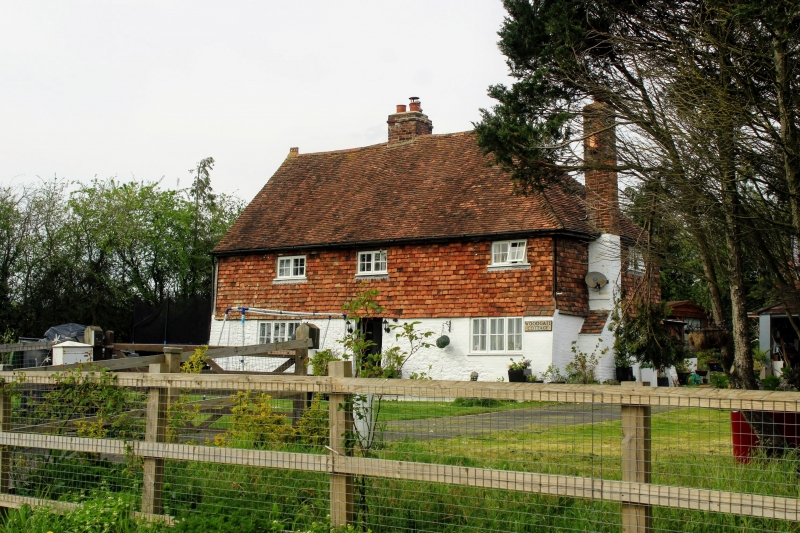
Entry Name: Woodgate Cottages
Listing Date: 25 February 1987
Grade: II
Source: Historic England
Source ID: 1110844
English Heritage Legacy ID: 179201
ID on this website: 101110844
Location: Addington, Tonbridge and Malling, Kent, ME19
County: Kent
District: Tonbridge and Malling
Civil Parish: Addington
Traditional County: Kent
Lieutenancy Area (Ceremonial County): Kent
Church of England Parish: Addington St Margaret
Church of England Diocese: Rochester
Tagged with: Cottage
ADDINGTON CP WOODGATE ROAD
TQ 65 NE
(north side)
7/20
Woodgate Cottages
-
- II
Farmhouse, now house. C17. Timber-framed with ground floor partly red brick,
partly random rubble stone, and tile-hung 1st floor. Plain tiled roof, hipped
to right with central ridge stack. Baffle entry plan. 2 storeys; 3-window
front, metal casements. Central boarded door.
Listing NGR: TQ6574359622
External links are from the relevant listing authority and, where applicable, Wikidata. Wikidata IDs may be related buildings as well as this specific building. If you want to add or update a link, you will need to do so by editing the Wikidata entry.


Other nearby listed buildings
