Approximate Location Map
Large Map »
Latitude: 51.4495 / 51°26'58"N
Longitude: -0.9902 / 0°59'24"W
OS Eastings: 470270
OS Northings: 172760
OS Grid: SU702727
Mapcode National: GBR QGH.PV
Mapcode Global: VHDWS.STDP
Plus Code: 9C3XC2X5+QW
Entry Name: Water Tower
Listing Date: 14 December 1978
Grade: II
Source: Historic England
Source ID: 1113397
English Heritage Legacy ID: 38755
ID on this website: 101113397
Location: Coley, Reading, Berkshire, RG1
County: Reading
Electoral Ward/Division: Minster
Parish: Non Civil Parish
Built-Up Area: Reading
Traditional County: Berkshire
Lieutenancy Area (Ceremonial County): Berkshire
Church of England Parish: St Mark and All Saints, Reading
Church of England Diocese: Oxford
Tagged with: Water tower Architectural structure
5128 BATH ROAD
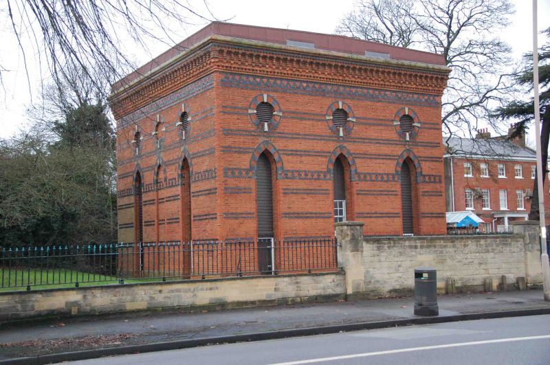
Water Tower
SU 7072
13/404
II
Circa 1870. A large 2 stage red brick square structure with grey brick bands
at intervals, decorative at impost and top levels and with cogged and moulded
bracket cornice to blocking course. Each side has 3 tall lancets with grey
and red brick voussoirs and stone keyed oculi above.
Listing NGR: SU7027072760
External links are from the relevant listing authority and, where applicable, Wikidata. Wikidata IDs may be related buildings as well as this specific building. If you want to add or update a link, you will need to do so by editing the Wikidata entry.


Other nearby listed buildings
