Approximate Location Map
Large Map »
Latitude: 51.4514 / 51°27'5"N
Longitude: -0.9799 / 0°58'47"W
OS Eastings: 470978
OS Northings: 172985
OS Grid: SU709729
Mapcode National: GBR QJH.Z4
Mapcode Global: VHDWS.YST6
Plus Code: 9C3XF22C+H2
Entry Name: 115, Castle Street
Listing Date: 14 December 1978
Grade: II
Source: Historic England
Source ID: 1113423
English Heritage Legacy ID: 38812
ID on this website: 101113423
Location: Coley, Reading, Berkshire, RG1
County: Reading
Electoral Ward/Division: Minster
Parish: Non Civil Parish
Built-Up Area: Reading
Traditional County: Berkshire
Lieutenancy Area (Ceremonial County): Berkshire
Church of England Parish: Reading St Giles
Church of England Diocese: Oxford
Tagged with: Building
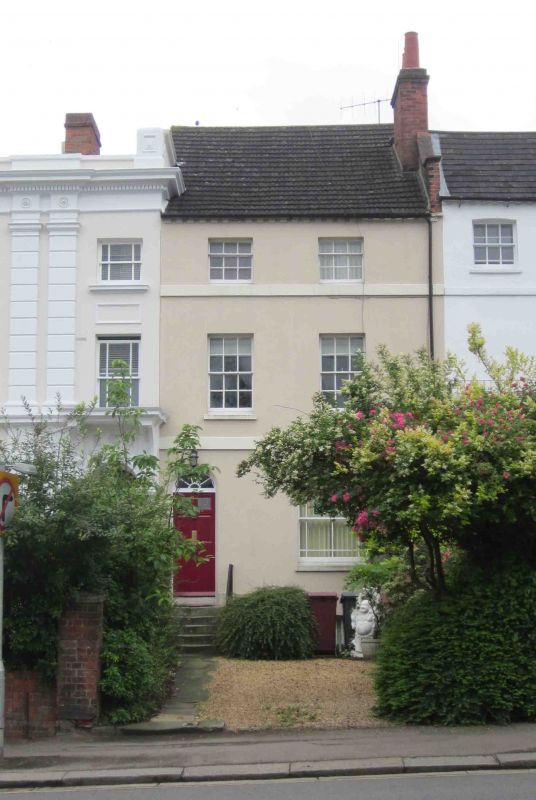
CASTLE STREET
1.
5128
(South Side)
Castle Hill
No 115
SU 7172 13/422
II GV
2.
Same build as Nos 117-121 (odd), but slightly set down. After 1823. 3 storeys
and basement, rendered. Plat band. 2nd floor cill band. Brick block eaves
cornice. Slate roof. 2 ranges of glazing bar sash windows. 6 panel door
to left with radiating fanlight.
Listing NGR: SU7097872985
External links are from the relevant listing authority and, where applicable, Wikidata. Wikidata IDs may be related buildings as well as this specific building. If you want to add or update a link, you will need to do so by editing the Wikidata entry.


Other nearby listed buildings
