Approximate Location Map
Large Map »
Latitude: 51.444 / 51°26'38"N
Longitude: -0.9577 / 0°57'27"W
OS Eastings: 472535
OS Northings: 172178
OS Grid: SU725721
Mapcode National: GBR QPK.YT
Mapcode Global: VHDWT.CY2Y
Plus Code: 9C3XC2VR+HW
Entry Name: The Mount
Listing Date: 14 December 1978
Last Amended: 16 May 1979
Grade: II
Source: Historic England
Source ID: 1113438
English Heritage Legacy ID: 38844
ID on this website: 101113438
Location: The Mount, Reading, Berkshire, RG1
County: Reading
Electoral Ward/Division: Redlands
Parish: Non Civil Parish
Built-Up Area: Reading
Traditional County: Berkshire
Lieutenancy Area (Ceremonial County): Berkshire
Church of England Parish: Reading Christ Church
Church of England Diocese: Oxford
Tagged with: Building Terrace of houses
In the entries for
CHRISTCHURCH ROAD
(north side)
The Mount
Nos 6 and 24 to 36 (even)
Nos 8 to 22 (even)
Nos 23 and 25
Nos 38 and 40
Nos 57 and 57A
Wall between Boa 57 and 59
No 59 (Uplands)
9/439
the street name shall be amended to read
THE MOUNT
------------------------------------
CHRISTCHURCH ROAD
(north side)
The Mount
Nos 6 and 24 to 36 (even)
Nos 8 to 22 (even)
Nos 23 and 25
Nos 38 and 40
Nos 57 and 57A
9/434 Wall between Nos 57 and 59
No 59 (Uplands )
the street name shall be amended to read
THE MOUNT
------------------------------------
CHRISTCHURCH ROAD
(north side)
The Mount
Nos 6 and 24 to 36 (even)
Nos 8 to 22 (even)
Nos 23 and 25
9/436 Nos 58 and 40
Nos 57 and 57A
Wall between Nos 57 and 59
No 59 (Uplands )
the street name ehall be amended to read
THE MOUNT
------------------------------------
CHRISTCHURCH ROAD
(north side)
9/433
The Mount
Nos 6 and 24 to 36 (even)
Nos 8 to 22 (even)
Nos 25 and 25
Nos 58 and 40
Nos 57 and 57A
Wall between Nos 57 and 59
No 59 (Uplands )
the street name shall be amended to read
THE MOUNT
------------------------------------
CHRISTCHURCH ROAD
1.
5128 (North Side)
The Mount
Nos 6 and 24 to 36 (even)
SU 7272 9/433
II GV
2.
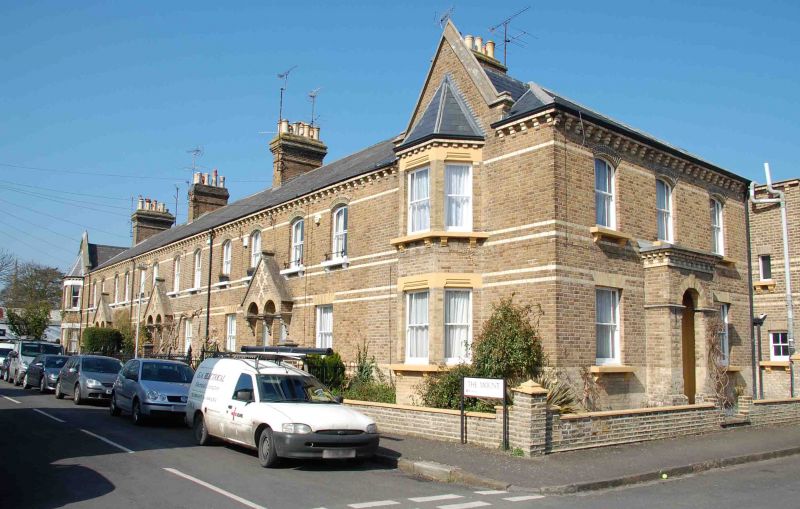
Circa 1876. A 2 storey terrace for the clerks at Huntley and Palmer's Biscuit
Factory with foremen's end terrace houses. Gault brick with white brick bands
and chevron-moulded 1st floor brick window arches. Modillion eaves cornice.
Slate roof with 4 principal chimney stacks with cogged capping. Marginally
glazed sash windows with bracket cills and cast iron flower basket guards.
The end houses Nos 6 and 24 have 2 storey bays capped by gables with moulded
coping, these windows have stop moulded lintels. Entered from side which has
3 window elevation with projecting central doors with rectangular overlight.
Nos 26 to 36 (even) have 2 windows each, ground floor windows with white and
yellow brick flat arches. Paired doorways with bracketed arch entrance and
joint gable over. Railings and standards retained, except for No 6. 2 storey
rear extensions, attic windows to rear of Nos 6 and 24. Internal features
(ceiling rosettes, mahogony rail to stairs which have curly bottom and plasterwork features) are retained in No 6 and several of the other houses.
Listing NGR: SU7253472178
External links are from the relevant listing authority and, where applicable, Wikidata. Wikidata IDs may be related buildings as well as this specific building. If you want to add or update a link, you will need to do so by editing the Wikidata entry.


Other nearby listed buildings
