Approximate Location Map
Large Map »
Latitude: 51.9645 / 51°57'52"N
Longitude: -0.5143 / 0°30'51"W
OS Eastings: 502170
OS Northings: 230597
OS Grid: TL021305
Mapcode National: GBR G41.W7W
Mapcode Global: VHFR0.1WGD
Plus Code: 9C3XXF7P+Q7
Entry Name: Redhills Farmhouse
Listing Date: 26 September 1980
Grade: II
Source: Historic England
Source ID: 1114744
English Heritage Legacy ID: 36104
ID on this website: 101114744
Location: Central Bedfordshire, LU5
County: Central Bedfordshire
Civil Parish: Toddington
Traditional County: Bedfordshire
Lieutenancy Area (Ceremonial County): Bedfordshire
Church of England Parish: Harlington
Church of England Diocese: St.Albans
Tagged with: Farmhouse
1.
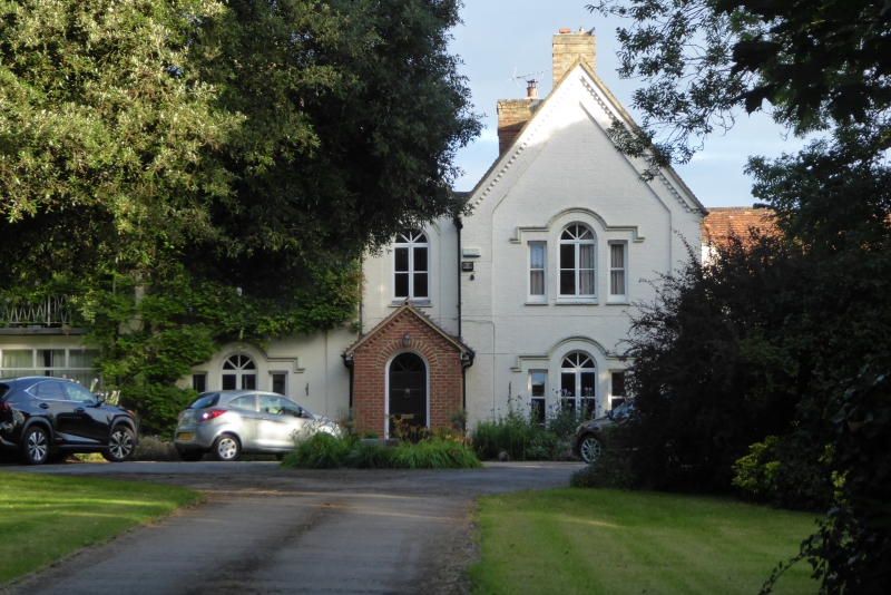
5125 TODDINGTON HARLINGTON ROAD
Redhills Farmhouse
TL 03 SW 1/319
II
2.
C16 with later alterations and additions. Timber-frame with colourwashed brick
nogging. Two storeys. Old clay tile roof. C19 gabled front. Two projecting
side gables with small central gable. Venetian windows with drip mouldings.
Listing NGR: TL0217030597
External links are from the relevant listing authority and, where applicable, Wikidata. Wikidata IDs may be related buildings as well as this specific building. If you want to add or update a link, you will need to do so by editing the Wikidata entry.


Other nearby listed buildings
