Approximate Location Map
Large Map »
Latitude: 51.9473 / 51°56'50"N
Longitude: -0.5328 / 0°31'58"W
OS Eastings: 500939
OS Northings: 228658
OS Grid: TL009286
Mapcode National: GBR G46.XT3
Mapcode Global: VHFR5.QB62
Plus Code: 9C3XWFW8+WV
Entry Name: 19, High Street
Listing Date: 26 September 1980
Grade: II
Source: Historic England
Source ID: 1114745
English Heritage Legacy ID: 36106
ID on this website: 101114745
Location: Toddington, Central Bedfordshire, LU5
County: Central Bedfordshire
Civil Parish: Toddington
Built-Up Area: Toddington
Traditional County: Bedfordshire
Lieutenancy Area (Ceremonial County): Bedfordshire
Church of England Parish: Toddington
Church of England Diocese: St.Albans
Tagged with: Building
1.
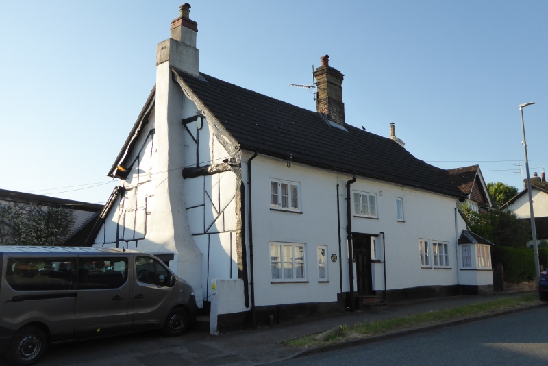
5125 TODDINGTON HIGH STREET
(east side)
No 19
TL 0028 20/321
II
2.
C17 much altered. Stucco. Two storeys. Slate roof, 3 casement windows. Canted
bay window in one storey lean-to on right.
Timber-frame visible in left hand gable end.
Listing NGR: TL0093928658
External links are from the relevant listing authority and, where applicable, Wikidata. Wikidata IDs may be related buildings as well as this specific building. If you want to add or update a link, you will need to do so by editing the Wikidata entry.


Other nearby listed buildings
