Approximate Location Map
Large Map »
Latitude: 51.0518 / 51°3'6"N
Longitude: 0.63 / 0°37'48"E
OS Eastings: 584429
OS Northings: 131338
OS Grid: TQ844313
Mapcode National: GBR QW6.XSF
Mapcode Global: FRA D66B.P81
Plus Code: 9F323J2J+P2
Entry Name: 12-18, High Street
Listing Date: 9 August 1979
Grade: II
Source: Historic England
Source ID: 1115702
English Heritage Legacy ID: 180334
ID on this website: 101115702
Location: Rolvenden, Ashford, Kent, TN17
County: Kent
District: Ashford
Civil Parish: Rolvenden
Built-Up Area: Rolvenden
Traditional County: Kent
Lieutenancy Area (Ceremonial County): Kent
Tagged with: Building
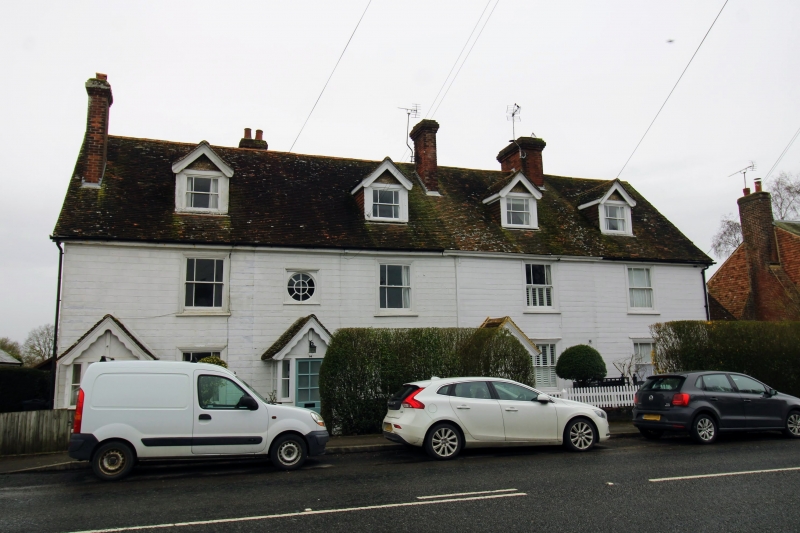
ROLVENDEN HIGH STREET
1.
5272
(west side)
Nos 12 to 18 (even)
TQ 8431 18/290
II GV
2.
Early C19 range. Two storeys wood, painted and grooved to resemble masonry.
Tiled roof with 4 gabled dormers. Four sashes without glazing bars and oculus
to No 14. Gabled weatherporches except to No 18 which has a weather hood
on wooden brackets.
Listing NGR: TQ8443031335
External links are from the relevant listing authority and, where applicable, Wikidata. Wikidata IDs may be related buildings as well as this specific building. If you want to add or update a link, you will need to do so by editing the Wikidata entry.


Other nearby listed buildings
