Approximate Location Map
Large Map »
Latitude: 51.8915 / 51°53'29"N
Longitude: -0.7854 / 0°47'7"W
OS Eastings: 483684
OS Northings: 222139
OS Grid: SP836221
Mapcode National: GBR D20.69S
Mapcode Global: VHDTS.BQN9
Plus Code: 9C3XV6R7+JV
Entry Name: Manor Farmhouse
Listing Date: 6 July 1984
Grade: II
Source: Historic England
Source ID: 1116030
English Heritage Legacy ID: 350754
ID on this website: 101116030
Location: Cublington, Buckinghamshire, LU7
County: Buckinghamshire
Civil Parish: Cublington
Built-Up Area: Cublington
Traditional County: Buckinghamshire
Lieutenancy Area (Ceremonial County): Buckinghamshire
Church of England Parish: CublingtonSt Nicholas
Church of England Diocese: Oxford
Tagged with: Farmhouse
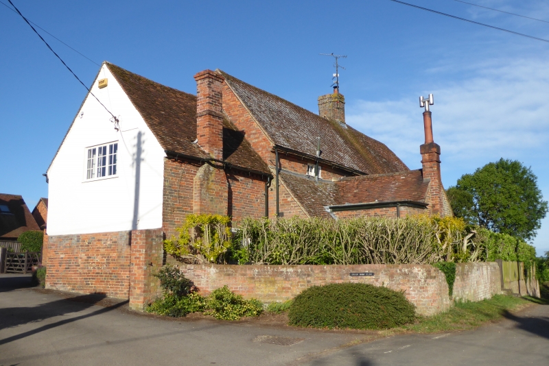
SP 82 SW CUBLINGTON RIDINGS WAY
5/17 Manor Farmhouse
II
House. Mid C18, altered C19. Right bay and ground floor of centre
bay are of red brick with diaper patterning in blue brick, moulded
plinth and plain first floor band course. Right bay has moulded
eaves. Left bay and first floor of centre bay rebuilt or extended
in red brick with off-set eaves Tiled roof, brick chimney between
right bays. 2 storeys and attic,3 bays. Right bay has 3-light
casements, barred wooden to ground floor, leaded to first floor.
Centre bay has 4-light barred wooden casement to ground floor and
similar 2-light above. Left bay has small horizontal sliding sash
over single-storey gabled projection with 4-pane sash to right
side and lean-to to left. Gabled porch between right bays is of
chequer brick with round windows to sides and render to front.
Blocked round window above porch 6-panelled door, top-lit,
has early C19 doorcase of fluted pilaster strips, lozenge panel
frieze and cornice hood on cut brackets. Lower C19 extension to
left with dentilled eaves. Right gable rendered and whitewashed with
paired leaded casement to attic.
Listing NGR: SP8368422139
External links are from the relevant listing authority and, where applicable, Wikidata. Wikidata IDs may be related buildings as well as this specific building. If you want to add or update a link, you will need to do so by editing the Wikidata entry.


Other nearby listed buildings
