Approximate Location Map
Large Map »
Latitude: 52.5632 / 52°33'47"N
Longitude: -1.8203 / 1°49'13"W
OS Eastings: 412276
OS Northings: 296168
OS Grid: SP122961
Mapcode National: GBR 3KB.M1
Mapcode Global: WHCH8.0TGV
Plus Code: 9C4WH57H+7V
Entry Name: 57 and 59, Coleshill Street
Listing Date: 26 August 1976
Grade: II
Source: Historic England
Source ID: 1116431
English Heritage Legacy ID: 216561
ID on this website: 101116431
Location: Royal Sutton Coldfield, Birmingham, West Midlands, B72
County: Birmingham
Civil Parish: Sutton Coldfield
Built-Up Area: Sutton Coldfield
Traditional County: Warwickshire
Lieutenancy Area (Ceremonial County): West Midlands
Church of England Parish: Sutton Coldfield Holy Trinity
Church of England Diocese: Birmingham
Tagged with: Building
1.
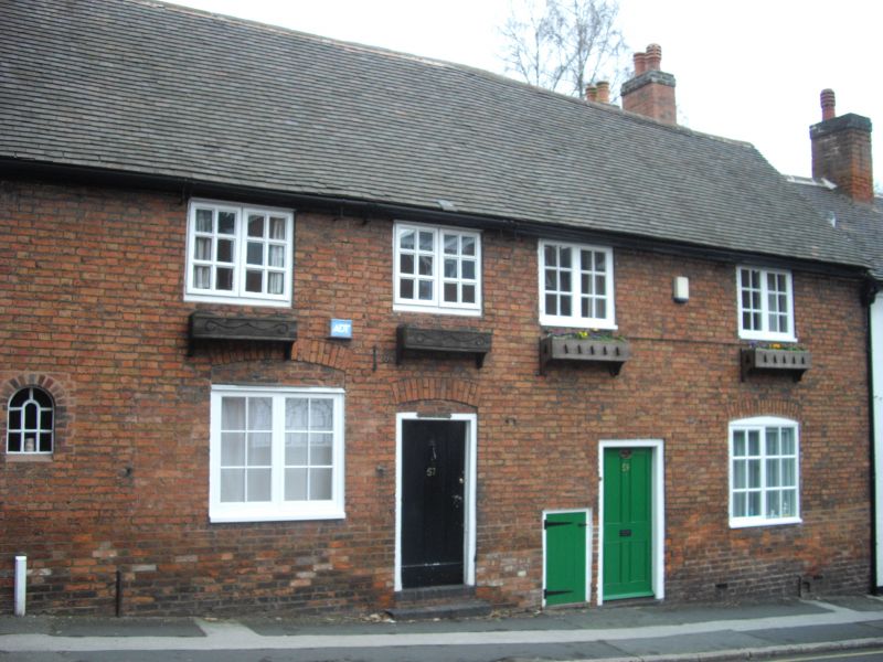
5104 COLESHILL STREET
(East Side)
Nos 57 and 59
SP 1296 1/90
II GV
2.
C19. Red brick, tiled roof. 2 storeys, 4 flush casement windows with glazing
bars, ground floor cambered arches and small window on left. Included for group
value.
Nos 43 to 63 (odd) form a group.
Listing NGR: SP1227696171
External links are from the relevant listing authority and, where applicable, Wikidata. Wikidata IDs may be related buildings as well as this specific building. If you want to add or update a link, you will need to do so by editing the Wikidata entry.


Other nearby listed buildings
