Approximate Location Map
Large Map »
Latitude: 51.2804 / 51°16'49"N
Longitude: 1.0776 / 1°4'39"E
OS Eastings: 614727
OS Northings: 157968
OS Grid: TR147579
Mapcode National: GBR TY2.P84
Mapcode Global: VHLGM.M2JT
Plus Code: 9F3373JH+42
Entry Name: 52, St Peter's Street
Listing Date: 7 September 1973
Grade: II
Source: Historic England
Source ID: 1116666
English Heritage Legacy ID: 442978
ID on this website: 101116666
Location: Canterbury, Kent, CT1
County: Kent
District: Canterbury
Electoral Ward/Division: Westgate
Parish: Non Civil Parish
Built-Up Area: Canterbury
Traditional County: Kent
Lieutenancy Area (Ceremonial County): Kent
Tagged with: Building
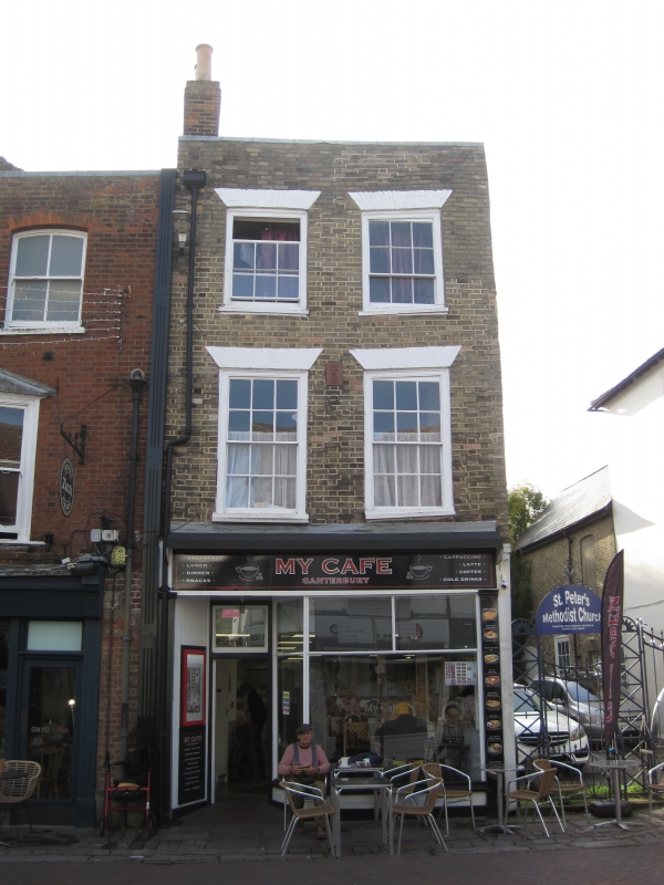
1.
944 ST PETER'S STREET
No 52
TR 1457 NE 4/690
II GV
2.
Cl8. 3 storeys buff brick. Rainwater head. 2 sashes with glazing bars intact
set in moulded architraves. Later shop front. The side elevation has 3 sashes,
2 of them blank, and a round-headed doorcase. Rear elevation is tile-hung.
Nos 49 to 60 (consec), Methodist Church and forecourt to Methodist Church
form a group.
Listing NGR: TR1472157960
External links are from the relevant listing authority and, where applicable, Wikidata. Wikidata IDs may be related buildings as well as this specific building. If you want to add or update a link, you will need to do so by editing the Wikidata entry.


Other nearby listed buildings
