Approximate Location Map
Large Map »
Latitude: 51.4094 / 51°24'33"N
Longitude: -1.2872 / 1°17'14"W
OS Eastings: 449669
OS Northings: 168060
OS Grid: SU496680
Mapcode National: GBR 81T.KD1
Mapcode Global: VHCZC.MTVX
Plus Code: 9C3WCP57+Q4
Entry Name: Lower Henwick Farmhouse
Listing Date: 10 November 1983
Grade: II
Source: Historic England
Source ID: 1117252
English Heritage Legacy ID: 39652
ID on this website: 101117252
Location: West Berkshire, RG18
County: West Berkshire
Civil Parish: Thatcham
Traditional County: Berkshire
Lieutenancy Area (Ceremonial County): Berkshire
Church of England Parish: Thatcham
Church of England Diocese: Oxford
Tagged with: Farmhouse
THATCHAM
SU 46NE
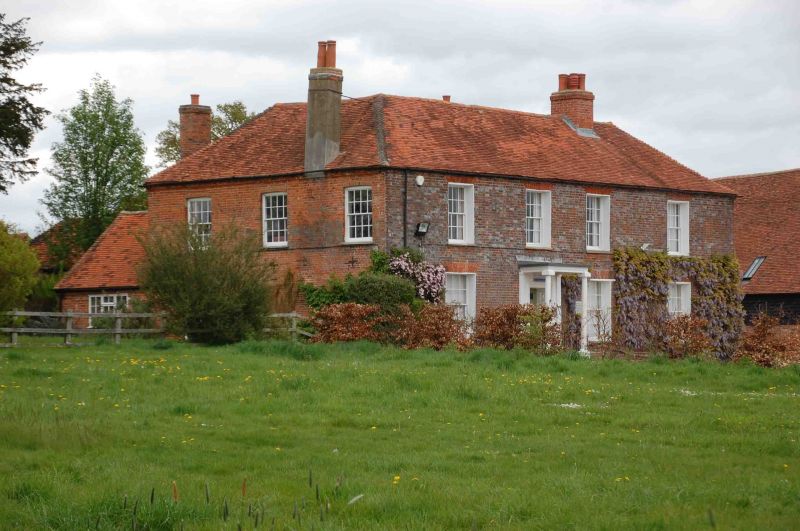
Lower Henwick Farmhouse
1/1
GV II
Farmhouse. Early C19. Grey brick with red dressings and hipped old tile roof. End
stack to left and stack off centre to left. 2 storeys; 4 bays with glazing bar
sashes. Doorway in second bay from left with 6 panelled door, moulded architrave,
panelled reveals and Doric porch. Some internal timber framing.
Listing NGR: SU4966968060
External links are from the relevant listing authority and, where applicable, Wikidata. Wikidata IDs may be related buildings as well as this specific building. If you want to add or update a link, you will need to do so by editing the Wikidata entry.


Other nearby listed buildings
