Approximate Location Map
Large Map »
Latitude: 51.4103 / 51°24'37"N
Longitude: -0.8335 / 0°50'0"W
OS Eastings: 481223
OS Northings: 168563
OS Grid: SU812685
Mapcode National: GBR D7R.D2Z
Mapcode Global: VHDX2.HTP7
Plus Code: 9C3XC568+4H
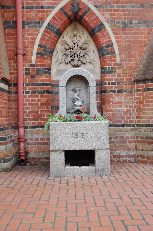
Entry Name: Drinking Fountain, Approximately One Metre from North East Corner of the Town Hall
Listing Date: 2 October 1969
Grade: II
Source: Historic England
Source ID: 1118057
English Heritage Legacy ID: 41683
ID on this website: 101118057
Location: Wokingham, Berkshire, RG40
County: Wokingham
Civil Parish: Wokingham
Built-Up Area: Wokingham
Traditional County: Berkshire
Lieutenancy Area (Ceremonial County): Berkshire
Church of England Parish: Wokingham
Church of England Diocese: Oxford
Tagged with: Drinking fountain
WOKINGHAM MARKET PLACE
SU 8168 NW
18/25 Drinking fountain, approximately
one metre from north east corner
2.10.69 of Town Hall
G.V. II
Drinking fountain, now disused. Dated 1881. Granite with dolphin design
outlet, and semi-circular top.
Listing NGR: SU8122368563
External links are from the relevant listing authority and, where applicable, Wikidata. Wikidata IDs may be related buildings as well as this specific building. If you want to add or update a link, you will need to do so by editing the Wikidata entry.


Other nearby listed buildings
