Approximate Location Map
Large Map »
Latitude: 51.3913 / 51°23'28"N
Longitude: -1.0045 / 1°0'16"W
OS Eastings: 469362
OS Northings: 166274
OS Grid: SU693662
Mapcode National: GBR B51.QW2
Mapcode Global: VHDX5.J9T9
Plus Code: 9C3W9XRW+G6
Entry Name: The Elms
Listing Date: 29 April 1987
Grade: II
Source: Historic England
Source ID: 1118139
English Heritage Legacy ID: 41467
ID on this website: 101118139
Location: Grazeley, Wokingham, Berkshire, RG7
County: Wokingham
Civil Parish: Shinfield
Traditional County: Berkshire
Lieutenancy Area (Ceremonial County): Berkshire
Church of England Parish: Spencers Wood and Grazeley
Church of England Diocese: Oxford
Tagged with: Building
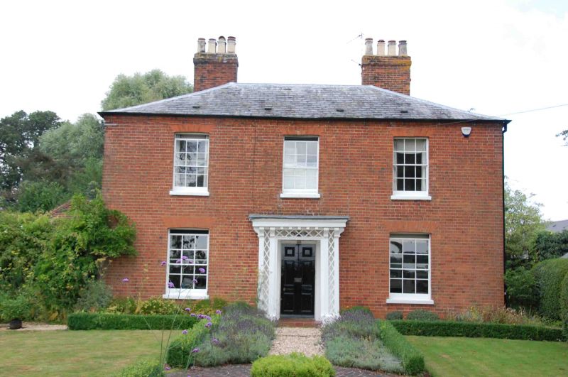
SHINFIELD LAMBWOOD HILL
U 66 NE (north west side)
Grazeley
7/4 The Elms
II
House. c1840. Brick, hipped slate roof. Square plan. 2 storeys.
Symmetrical chimneys with original pots. 3 bay front of sash windows
with glazing bars and 6-panelled central door, rectangular fanlight,
in C19 lattice and post porch.
Listing NGR: SU6936266274
External links are from the relevant listing authority and, where applicable, Wikidata. Wikidata IDs may be related buildings as well as this specific building. If you want to add or update a link, you will need to do so by editing the Wikidata entry.


Other nearby listed buildings
