Approximate Location Map
Large Map »
Latitude: 51.5387 / 51°32'19"N
Longitude: -0.8733 / 0°52'23"W
OS Eastings: 478241
OS Northings: 182802
OS Grid: SU782828
Mapcode National: GBR C4T.G1L
Mapcode Global: VHDWG.TL69
Plus Code: 9C3XG4QG+FM
Entry Name: Remenham Hill Terrace
Listing Date: 23 December 1983
Grade: II
Source: Historic England
Source ID: 1118188
English Heritage Legacy ID: 41274
ID on this website: 101118188
Location: Remenham Hill, Wokingham, Berkshire, RG9
County: Wokingham
Civil Parish: Remenham
Traditional County: Berkshire
Lieutenancy Area (Ceremonial County): Berkshire
Church of England Parish: Remenham
Church of England Diocese: Oxford
Tagged with: Building
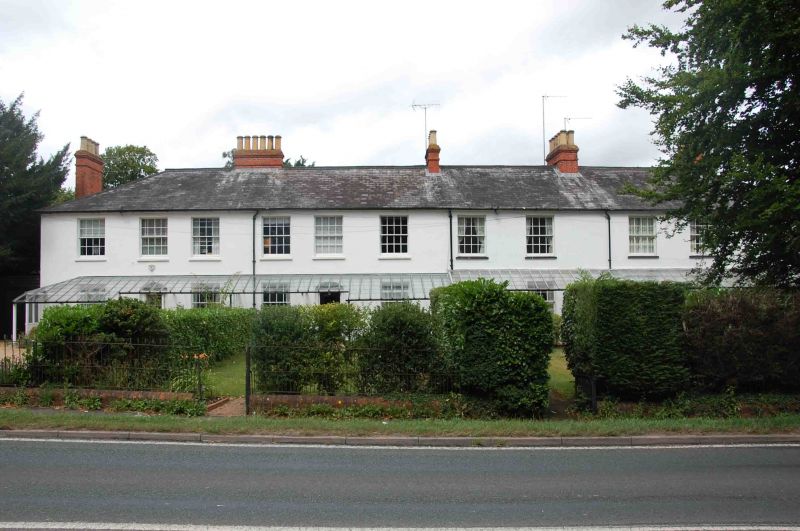
REMENHAM REMENHAM HILL
SU 78 SE
(north side)
1/14 Nos 1-5 (odd) (Remenham
Hill Terrace)
II
Terrace of 5 houses. Early C19 painted stucco, hipped slate roof. 2 storeys.
Road front: 11 bays sash windows with glazing bars, half glazed entrance doors
with half elliptical radiating fanlights. The whole of the ground floor is
under a glazed roofed verandah.
Listing NGR: SU7824182802
External links are from the relevant listing authority and, where applicable, Wikidata. Wikidata IDs may be related buildings as well as this specific building. If you want to add or update a link, you will need to do so by editing the Wikidata entry.


Other nearby listed buildings
