Approximate Location Map
Large Map »
Latitude: 50.729 / 50°43'44"N
Longitude: -2.4569 / 2°27'24"W
OS Eastings: 367851
OS Northings: 92254
OS Grid: SY678922
Mapcode National: GBR PY.4GMP
Mapcode Global: FRA 57R4.STL
Plus Code: 9C2VPGHV+J7
Entry Name: The Riding House
Listing Date: 26 January 1956
Last Amended: 10 March 1987
Grade: II*
Source: Historic England
Source ID: 1119102
English Heritage Legacy ID: 106224
ID on this website: 101119102
Location: Charminster, Dorset, DT2
County: Dorset
Civil Parish: Charminster
Traditional County: Dorset
Lieutenancy Area (Ceremonial County): Dorset
Church of England Parish: Charminster St Mary the Virgin
Church of England Diocese: Salisbury
Tagged with: House
CHARMINSTER
WOLFETON
SY 6792
13/36 The Riding House
(formerly listed as
26.1.56 Wolfeton Barn)
- II*
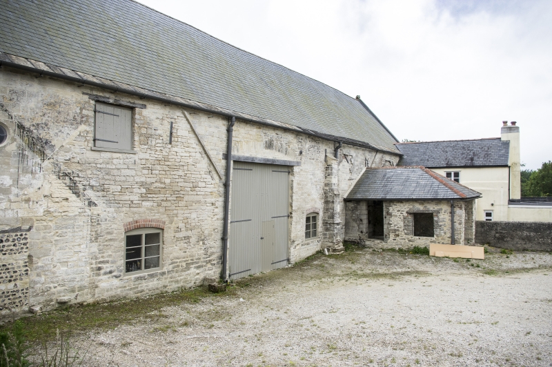
Riding House. Late C16. Ashlar stone walls on the east, south and west,
squared and coursed rubble on the north. Later alterations are in coursed
rubble of poor quality. Slate roof with gable ends. South elevation has a
plinth with chamfered footing course and ogee moulded capping, divided into
7 bays by weathered buttresses, easterly bay thrice normal width. Secondary
external stone stair in westerly bay with buttress removed. Centre of wide
east bay, round headed doorway, with plinth mouldings returned downwards
each side, above the doorway is a small carved lion mask. The fourth and
south bays from the east, mullioned windows of 3 square headed lights,
blocked, with weathered labels. Remains of a similar label in the second
bay. Alterations: Bay 1: 2-light casement with segmental head inserted.
Bay 2: large openings to ground and upper floors, with planking. Bay 4:
small single light C20 window. Bay 6: plank doorway inserted with
segmental head, C19. Bay 7: plank doorway with segmental head at top of
secondary stair. West wall has 2 weathered buttresses and moulded plinths.
Round headed doorway to south with continuous ogee and hollow chamfered
mouldings. Two 3-light mullion windows, ground and upper storey with
labels. North elevation: weathered buttress near the north east corner,
and another buttress near the middle of the elevation. Blocked round window
near eastern buttress and 2 blocked rectangular openings near the eaves.
All other openings on the north elevation are secondary. The large barn
doorway may well replace a narrower original doorway. East wall has plinth,
buttresses, upper window. Five small round windows in two tiers. Interior:
original first floor removed, but most of the beams upon which it rested
remain, chamfered and measure 300 mm by 300 mm in section. The beams
supported both a floor and independent ceiling. To the north the beams are
housed in the wall; to the south they rest on rounded stone corbels which
project from the wall directly above the level of timber lintels spanning
the window recesses. The roof has been extensively strutted and repaired.
As a building type, this is of considerable architectural importance. (RCHM
Dorset III p 69(5) for fuller description, plan, elevations and plate)
Listing NGR: SY6785192254
External links are from the relevant listing authority and, where applicable, Wikidata. Wikidata IDs may be related buildings as well as this specific building. If you want to add or update a link, you will need to do so by editing the Wikidata entry.


Other nearby listed buildings
