Approximate Location Map
Large Map »
Latitude: 54.7731 / 54°46'23"N
Longitude: -1.5726 / 1°34'21"W
OS Eastings: 427593
OS Northings: 542106
OS Grid: NZ275421
Mapcode National: GBR KFG7.BR
Mapcode Global: WHC4Q.T9B6
Plus Code: 9C6WQCFG+6X
Entry Name: Kingsgate Bridge
Listing Date: 29 May 1998
Grade: I
Source: Historic England
Source ID: 1119766
English Heritage Legacy ID: 469295
ID on this website: 101119766
Location: The Sands, County Durham, DH1
County: County Durham
Electoral Ward/Division: Elvet and Gilesgate
Parish: City of Durham
Built-Up Area: Durham
Traditional County: Durham
Lieutenancy Area (Ceremonial County): County Durham
Church of England Parish: Durham St Oswald
Church of England Diocese: Durham
Tagged with: Footbridge
NZ 24 SE DURHAM AND FRAMWELLGATE RIVER WEAR
1914/6/10001 Kingsgate Bridge
GV I
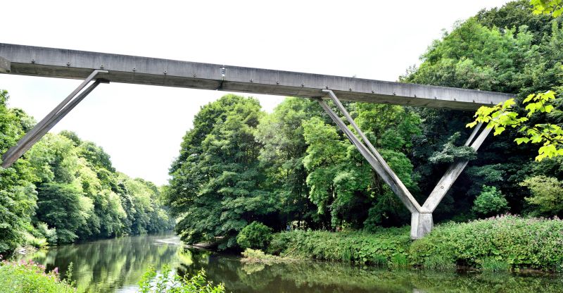
Footbridge over river. 1963.
Ove Arup and Partners (Ove Arup, engineer). Reinforced concrete;
concrete made with white cement and Shap granite and surfaces grit blasted. Consists of two trough shaped lengths of deck, each supported by V shaped legs on single support at base of V. Halves constructed on banks and rotated about base support to meet over middle of river. Connected by bronze expansion joints in the parapets which are in fonn of a T and a U turned through 90 degrees and interlocking, said to symbolise connection of Town and University. Deck drained by water spouts at regular intervals, which give rhythm to the elevations. Tops of parapets shaped for structural reasons and to provide surface comfortable to the touch. This dramatic, beautifully detailed and ingenious bridge was designed by Sir Ove Arup personally and was commissioned by the University of Durham.
Civic Trust Award 1965. Winner, Concrete Society Certificate ofOutstandingPerfonnance (Mature Structures Category) 1993.
[Concrete Quarterly, January-March 1964]
Listing NGR: NZ2759342106
External links are from the relevant listing authority and, where applicable, Wikidata. Wikidata IDs may be related buildings as well as this specific building. If you want to add or update a link, you will need to do so by editing the Wikidata entry.


Other nearby listed buildings
