Approximate Location Map
Large Map »
Latitude: 50.6077 / 50°36'27"N
Longitude: -1.9553 / 1°57'19"W
OS Eastings: 403256
OS Northings: 78663
OS Grid: SZ032786
Mapcode National: GBR 459.Y6N
Mapcode Global: FRA 67SG.J1N
Plus Code: 9C2WJ25V+3V
Entry Name: 11 11A 13 15 17 17A, High Street
Listing Date: 26 June 1952
Last Amended: 21 March 1983
Grade: II
Source: Historic England
Source ID: 1119900
English Heritage Legacy ID: 108199
ID on this website: 101119900
Location: Swanage, Dorset, BH19
County: Dorset
Civil Parish: Swanage
Built-Up Area: Swanage
Traditional County: Dorset
Lieutenancy Area (Ceremonial County): Dorset
Church of England Parish: Swanage St Mary the Virgin
Church of England Diocese: Salisbury
Tagged with: Building
HIGH STREET
1.
5190
(south side)
Nos 11, 11a, 13, 15, 17 and 17a
(formerly listed as Nos 11, 13,
15, 17 and 17a)
SZ 0378 3M 5/73 26.6.52
II
2.
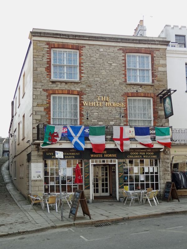
Built 1835. A terrace of shops, the ones at each end projecting slightly. Originally
rendered, but the rendering has recently been stripped from the 2 end buildings,
exposing Purbeck stone walls with brick window surrounds. Slate roofs. Cast iron
balconies to first floor. Double-hung sash windows to first and second floors. No 11,
now the White House Inn, has large modern small-paned windows to ground floor. Nos 11a
and 13, now a shop, were the retirement home of John Mowlem - later the "Queen's"
Restaurant. This has a C19 shop front. Above the roof is a projecting battlemented
tower, formerly John Mowlem's observatory. Below this are 3 inserted dormers. No 15
has a modern shop front and a large modern inserted dormer in the attic. No 17 has a
C19 shop front with projecting canted bays each side of a central door, and a dormer
in the attic. No 17a, at the rear of No 17, faces Cliff Place and was probably
originally a separate cottage, probably C18. Two storeys. Purbeck Stone walls and
roof. Modern windows and door. Stone boundary wall linking this building to Nos 1 and
2 Cliff Place - this appears to be the site of a demolished cottage. RCHM Monument 32.
Listing NGR: SZ0325678663
External links are from the relevant listing authority and, where applicable, Wikidata. Wikidata IDs may be related buildings as well as this specific building. If you want to add or update a link, you will need to do so by editing the Wikidata entry.


Other nearby listed buildings
