Approximate Location Map
Large Map »
Latitude: 50.6793 / 50°40'45"N
Longitude: -2.1564 / 2°9'22"W
OS Eastings: 389047
OS Northings: 86638
OS Grid: SY890866
Mapcode National: GBR 21M.7NH
Mapcode Global: FRA 67C8.XBV
Plus Code: 9C2VMRHV+PF
Entry Name: Holme Bridge
Listing Date: 20 November 1959
Last Amended: 30 June 2015
Grade: II*
Source: Historic England
Source ID: 1120572
English Heritage Legacy ID: 108346
ID on this website: 101120572
Location: Holmebridge, Dorset, BH20
County: Dorset
Civil Parish: East Stoke
Traditional County: Dorset
Lieutenancy Area (Ceremonial County): Dorset
Church of England Parish: Wool, East Burton and Combe Keynes
Church of England Diocese: Salisbury
Tagged with: Road bridge
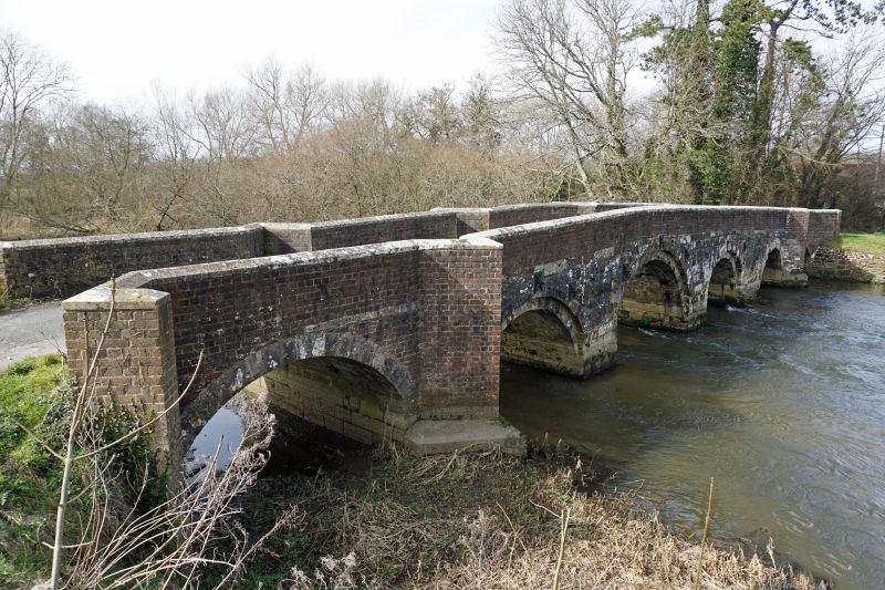
Bridge over River Frome. Early C17 origin, lengthened in late C17, C18 and C19. Repaired 1956.
Six-span bridge over the River Frome. Early C17 origin, lengthened in late C17, C18 and C19 and repaired in 1956.
MATERIALS: the earlier part of the structure is built of limestone and car-stone, lengthened with parapets rebuilt (1956) in brick with stone copings.
The oldest section has 3 stone arches of 2 orders - the central one higher - and springs from plain piers. The arch to the north, added in the late C17, is plain and built in stone, and that added in the C18 is built in brick. The C19 arch to the south is built in stone with brick spandrels. The west parapet has five cut-waters - also forming refuges - whilst the east has only two cut-waters.
Earlier bridges, dating from the 13th and 15th centuries, are believed to have occupied this site, though no fabric appears to have survived above ground or within the current bridge. The oldest part of the bridge probably dates from the early C17. In July 1674 at the Quarter Sessions the bridge was presented as being in great decay, and it was probably soon afterwards that a fourth segmental stone arch was built to the north. In the C18 an arch was added at the north end, and in the C19 a further one at the south end.
In 1945 Holme Bridge was damaged by military transport and in 1951 a Bailey Bridge was built immediately to its east. In 1956, Holme Bridge was restored by Dorset County Council and the Ministry of Works. In 1963 the Bailey Bridge was replaced with the current bridge, superseding the original Holme Bridge.
Holme Bridge, of early C17 origin, lengthened in late C17, C18 and C19, and repaired in 1956, is listed at Grade II* for the following principal reasons:
* Architectural interest and date: it is a particularly interesting and relatively rare survival of a bridge originating from the early C17 that displays particularly high quality architectural detailing and use of different materials;
* Historic Interest: its historic phasing as expressed in its repairs, extensions and modifications over successive centuries, and arguably the C20 too, reflect the particularly high level significance, evolution and development of this important route;
* Intactness: the bridge, despite having had some parts of its parapet rebuilt, has survived remarkably intact.
External links are from the relevant listing authority and, where applicable, Wikidata. Wikidata IDs may be related buildings as well as this specific building. If you want to add or update a link, you will need to do so by editing the Wikidata entry.


Other nearby listed buildings
