Approximate Location Map
Large Map »
Latitude: 54.7755 / 54°46'31"N
Longitude: -1.5723 / 1°34'20"W
OS Eastings: 427611
OS Northings: 542375
OS Grid: NZ276423
Mapcode National: GBR KFG6.DW
Mapcode Global: WHC4Q.T7HB
Plus Code: 9C6WQCGH+63
Entry Name: Half Moon Public House
Listing Date: 10 March 1988
Grade: II
Source: Historic England
Source ID: 1121418
English Heritage Legacy ID: 110293
ID on this website: 101121418
Location: The Sands, County Durham, DH1
County: County Durham
Electoral Ward/Division: Elvet and Gilesgate
Parish: City of Durham
Built-Up Area: Durham
Traditional County: Durham
Lieutenancy Area (Ceremonial County): County Durham
Church of England Parish: Durham St Oswald
Church of England Diocese: Durham
Tagged with: Pub
DURHAM AND FRAMWELLGATE
NZ2742 SE
15/241
NEW ELVET
(West side)
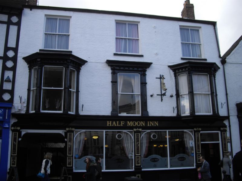
No. 86 (Half Moon
Public House)
GV
II
House, now public house and workshop. C17 and C18 with C19 public house front.
Painted brick; rear wing sandstone rubble ground floor and brick above, with
brick extension as joiner's shop; Welsh slate roofs with brick chimneys. 3
storeys, 3 bays. Late C19 pub front has panelled Ionic pilasters, entablature
and wide panelled door at right with overlight. Yard entrance at left. First
floor has central sash window flanked by oriels with pilasters and bracketed
cornices. Second floor has 3 late C19 sashes. Banded right end chimney. Rear
wing: nearest section 2 storeys and 3 windows with stone-bracketed hood of C17
type and 5 small C20 ground-floor windows; header-course lintels to first and
second windows above, flat stone lintel to inserted third sash window. Floor
band. Second building 3 storeys, 2 bays. One boarded door and one with 4
panels; sashes with glazing bars and loading doors on upper floors.
Interior: pub has mahogany semi-circular bar with fittings; matching chimney
piece. First building at rear has staircase with flat balusters and C17 newels
with ball finials. Stair in dangerous condition at time of survey. Furthest
rear building not of interest.
Listing NGR: NZ2761142375
External links are from the relevant listing authority and, where applicable, Wikidata. Wikidata IDs may be related buildings as well as this specific building. If you want to add or update a link, you will need to do so by editing the Wikidata entry.


Other nearby listed buildings
