History in Structure

South Bridge West Wycombe Park

A Grade II Listed Building in West Wycombe, Buckinghamshire

More Photos »
Approximate Location Map
Large Map »

Coordinates

Latitude: 51.6421 / 51°38'31"N

Longitude: -0.8008 / 0°48'2"W

OS Eastings: 483080

OS Northings: 194375

OS Grid: SU830943

Mapcode National: GBR D4W.VSH

Mapcode Global: VHDVY.2ZJL

Plus Code: 9C3XJ5RX+RM

Entry Name: South Bridge West Wycombe Park

Listing Date: 28 June 1973

Grade: II

Source: Historic England

Source ID: 1125086

English Heritage Legacy ID: 46170

ID on this website: 101125086
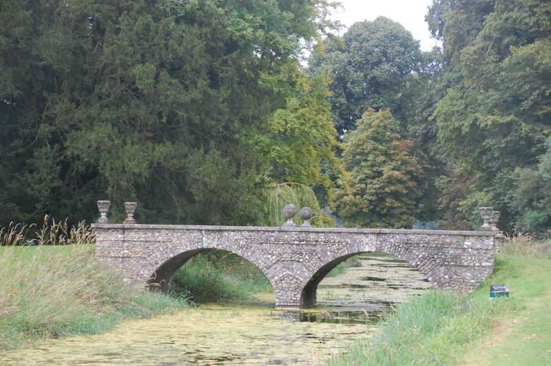
Location: West Wycombe, Buckinghamshire, HP14

County: Buckinghamshire

Civil Parish: West Wycombe

Traditional County: Buckinghamshire

Lieutenancy Area (Ceremonial County): Buckinghamshire

Church of England Parish: West Wycombe

Church of England Diocese: Oxford

Tagged with: Bridge Building

Find accommodation in
Bradenham

Description


WEST WYCOMBE
1.
963
South Bridge, West
Wycombe Park
SU 8394 10/329
II

2.
Late C18 or early C19. 2 arches of brick faced with flint rubble. Ashlar
parapet.


Listing NGR: SU8308094375

External Links

External links are from the relevant listing authority and, where applicable, Wikidata. Wikidata IDs may be related buildings as well as this specific building. If you want to add or update a link, you will need to do so by editing the Wikidata entry.

Recommended Books

Other nearby listed buildings

BritishListedBuildings.co.uk is an independent online resource and is not associated with any government department. All government data published here is used under licence. Please do not contact BritishListedBuildings.co.uk for any queries related to any individual listed building, planning permission related to listed buildings or the listing process itself.

British Listed Buildings is a Good Stuff website.