Approximate Location Map
Large Map »
Latitude: 51.6267 / 51°37'36"N
Longitude: -0.7415 / 0°44'29"W
OS Eastings: 487211
OS Northings: 192738
OS Grid: SU872927
Mapcode National: GBR D54.Z7J
Mapcode Global: VHDW5.3CCT
Plus Code: 9C3XJ7G5+MC
Entry Name: Rye Cottage
Listing Date: 28 June 1973
Grade: II
Source: Historic England
Source ID: 1125144
English Heritage Legacy ID: 46106
ID on this website: 101125144
Location: High Wycombe, Buckinghamshire, HP11
County: Buckinghamshire
Electoral Ward/Division: Ryemead
Parish: Non Civil Parish
Built-Up Area: High Wycombe
Traditional County: Buckinghamshire
Lieutenancy Area (Ceremonial County): Buckinghamshire
Church of England Parish: High Wycombe All Saints
Church of England Diocese: Oxford
Tagged with: Cottage
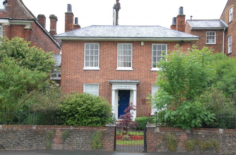
LONDON ROAD
1.
963
(North Side)
No 29
(Rye Cottage)
SU 8792 5/281
II GV
2.
Early C19. Red brick, hipped Welsh slate roof. 2 storeys, eaves cornice.
3 sashes in reveals with glazing bars, flat arches. Central Doric porch,
6 fielded panel door.
Nos 29 and 31 form a group.
Listing NGR: SU8721192738
External links are from the relevant listing authority and, where applicable, Wikidata. Wikidata IDs may be related buildings as well as this specific building. If you want to add or update a link, you will need to do so by editing the Wikidata entry.


Other nearby listed buildings
