Approximate Location Map
Large Map »
Latitude: 51.6298 / 51°37'47"N
Longitude: -0.7472 / 0°44'49"W
OS Eastings: 486811
OS Northings: 193080
OS Grid: SU868930
Mapcode National: GBR D54.PXG
Mapcode Global: VHDW5.09BD
Plus Code: 9C3XJ7H3+W4
Entry Name: The Flint Cottage Inn
Listing Date: 28 June 1973
Grade: II
Source: Historic England
Source ID: 1125206
English Heritage Legacy ID: 45956
ID on this website: 101125206
Location: High Wycombe, Buckinghamshire, HP13
County: Buckinghamshire
Electoral Ward/Division: Abbey
Parish: Non Civil Parish
Built-Up Area: High Wycombe
Traditional County: Buckinghamshire
Lieutenancy Area (Ceremonial County): Buckinghamshire
Church of England Parish: High Wycombe All Saints
Church of England Diocese: Oxford
Tagged with: Building
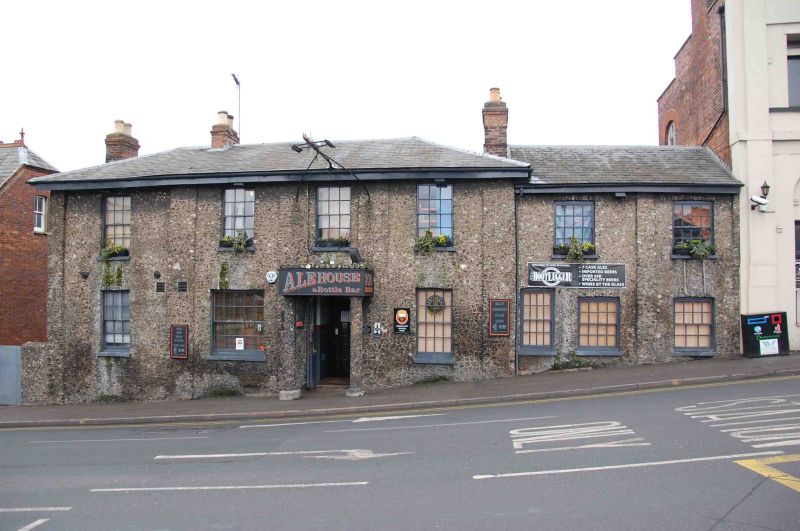
AMERSHAM HILL
1.
963
No 3
(The Flint Cottage Inn)
SU 8693 SE 2/214
II
2.
Mid C19. Flint rubble, low pitched Welsh slate roof. 2 storeys, pilasters,
4 sashes, mostly with glazing bars. Slightly lower north wing with 2 sashes.
Listing NGR: SU8681193080
External links are from the relevant listing authority and, where applicable, Wikidata. Wikidata IDs may be related buildings as well as this specific building. If you want to add or update a link, you will need to do so by editing the Wikidata entry.


Other nearby listed buildings
