Approximate Location Map
Large Map »
Latitude: 52.2038 / 52°12'13"N
Longitude: 0.1141 / 0°6'50"E
OS Eastings: 544567
OS Northings: 258278
OS Grid: TL445582
Mapcode National: GBR L78.ZL7
Mapcode Global: VHHK2.XVPY
Plus Code: 9F426437+GJ
Entry Name: King's College, King's Bridge
Listing Date: 26 April 1950
Grade: I
Source: Historic England
Source ID: 1125535
English Heritage Legacy ID: 47176
ID on this website: 101125535
Location: Cambridge, Cambridgeshire, CB3
County: Cambridgeshire
District: Cambridge
Electoral Ward/Division: Newnham
Parish: Non Civil Parish
Built-Up Area: Cambridge
Traditional County: Cambridgeshire
Lieutenancy Area (Ceremonial County): Cambridgeshire
Church of England Parish: Cambridge St Edward King and Martyr
Church of England Diocese: Ely
Tagged with: Footbridge
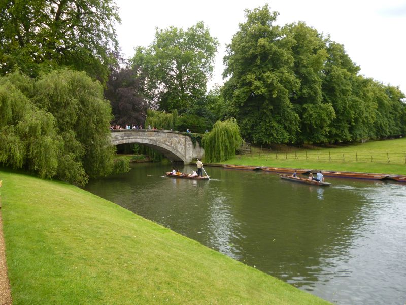
KING'S COLLEGE
1.
942
King's Bridge
TL 4458 SE 6/271 26.4.50.
I
2.
1818. By William Wilkins. Fifeshire stone ashlar. Single segmental span.
The site according to the 'picturesque' theory of landscaping. (RCHM).
Listing NGR: TL4456758278
External links are from the relevant listing authority and, where applicable, Wikidata. Wikidata IDs may be related buildings as well as this specific building. If you want to add or update a link, you will need to do so by editing the Wikidata entry.


Other nearby listed buildings
