Approximate Location Map
Large Map »
Latitude: 52.4571 / 52°27'25"N
Longitude: 0.0474 / 0°2'50"E
OS Eastings: 539211
OS Northings: 286325
OS Grid: TL392863
Mapcode National: GBR L43.SZK
Mapcode Global: VHHHW.RHXQ
Plus Code: 9F42F24W+VX
Entry Name: Burnsfield House
Listing Date: 22 March 1983
Grade: II
Source: Historic England
Source ID: 1125966
English Heritage Legacy ID: 48041
ID on this website: 101125966
Location: Chatteris, Fenland, Cambridgeshire, PE16
County: Cambridgeshire
District: Fenland
Civil Parish: Chatteris
Built-Up Area: Chatteris
Traditional County: Cambridgeshire
Lieutenancy Area (Ceremonial County): Cambridgeshire
Church of England Parish: Chatteris St Peter and St Paul
Church of England Diocese: Ely
Tagged with: House
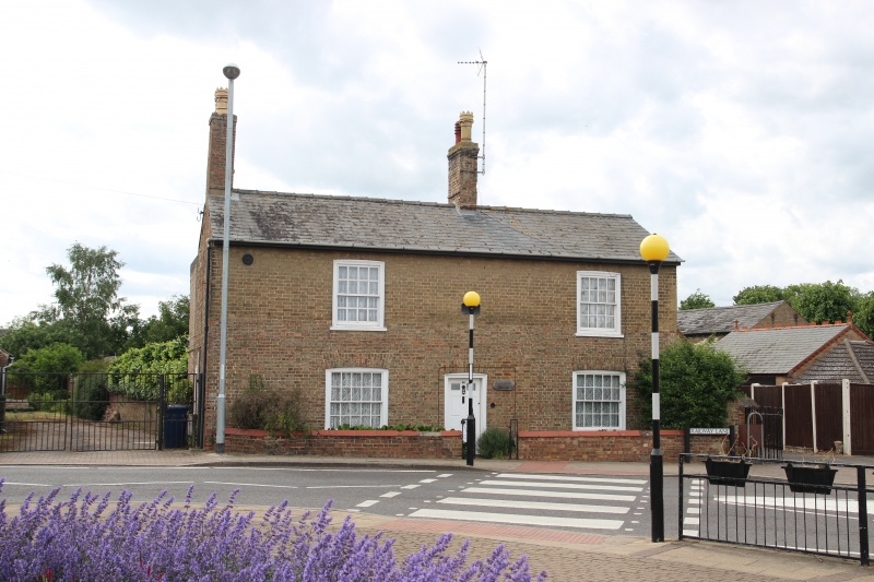
1.
5139
TL 383852
7/80
RAILWAY LANE
No 40 'Burnsfield House'
II
GV
2.
Late C18 cottage raised to 2 storeys in C19. L-plan. Local later gault brick,
slate roof with ridge and end stacks. Two hung sash windows with glazing bars in
segmental arches at first floor, similar windows flank central door of 2 glazed
panels and 4 panels.
Listing NGR: TL3921186325
External links are from the relevant listing authority and, where applicable, Wikidata. Wikidata IDs may be related buildings as well as this specific building. If you want to add or update a link, you will need to do so by editing the Wikidata entry.


Other nearby listed buildings
