Approximate Location Map
Large Map »
Latitude: 52.4008 / 52°24'2"N
Longitude: 0.2658 / 0°15'56"E
OS Eastings: 554245
OS Northings: 280498
OS Grid: TL542804
Mapcode National: GBR M6H.G0F
Mapcode Global: VHHJ6.KXCG
Plus Code: 9F42C728+88
Entry Name: 27 and 29, Newnham Street
Listing Date: 19 June 1972
Grade: II
Source: Historic England
Source ID: 1126492
English Heritage Legacy ID: 48765
ID on this website: 101126492
Location: Ely, East Cambridgeshire, CB7
County: Cambridgeshire
District: East Cambridgeshire
Civil Parish: Ely
Built-Up Area: Ely
Traditional County: Cambridgeshire
Lieutenancy Area (Ceremonial County): Cambridgeshire
Church of England Parish: Ely
Church of England Diocese: Ely
Tagged with: Building
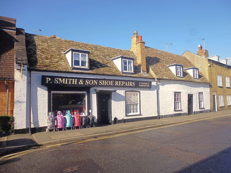
NEWNHAM STREET
1.
l082
Nos 27 & 29
TL 5480 1/178
II GV
2.
2 C18 painted brick cottages, I storey and attics. 4 window range,
double hung sashes with glazing bars, in flush cased frames. No 27 has
a C19 shop front. Roofs tiled, Old Cambridgeshire tiles, with 4 flat
headed dormers.
Nos 23 to 29 (odd) form a goup.
Listing NGR: TL5424580498
External links are from the relevant listing authority and, where applicable, Wikidata. Wikidata IDs may be related buildings as well as this specific building. If you want to add or update a link, you will need to do so by editing the Wikidata entry.


Other nearby listed buildings
