Approximate Location Map
Large Map »
Latitude: 51.5779 / 51°34'40"N
Longitude: -2.6377 / 2°38'15"W
OS Eastings: 355909
OS Northings: 186756
OS Grid: ST559867
Mapcode National: GBR JN.CZ2S
Mapcode Global: VH881.7LFQ
Plus Code: 9C3VH9H6+5W
Entry Name: Church Farmhouse
Listing Date: 5 December 1984
Grade: II
Source: Historic England
Source ID: 1128952
English Heritage Legacy ID: 35338
ID on this website: 101128952
Location: Northwick, South Gloucestershire, BS35
County: South Gloucestershire
Civil Parish: Pilning and Severn Beach
Built-Up Area: Pilning
Traditional County: Gloucestershire
Lieutenancy Area (Ceremonial County): Gloucestershire
Church of England Parish: St Peter Pilning
Church of England Diocese: Bristol
Tagged with: Farmhouse
ST 58 NE PILNING AND SEVERN NORTHWICK ROAD (north side)
BEACH Northwick
7/233
Church Farmhouse
G.V.
II
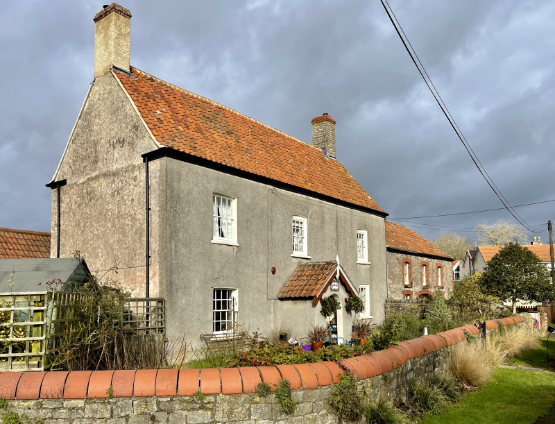
Farmhouse. C17, with C19 and later additions and alterations. Rubble to
right, brick to left, rendered at front and sides, pantiled roof with gable
stacks, double Roman tiled attached stable wing. Former through passage plan.
2 storeys and 3 windows, ground and 1st floor left 16-pane sashes, all sashes to
right, all with cambered heads, 2nd bay from left has gabled porch with
bargeboards and finial, door of 2 raised panels. East elevation has 2-light
casement at attic level, it storey, 3-bay stable attached, with cart entry and
three 4-pane sashes above, all openings with gauged brick segmental heads and
surrounds, brick quoins, stable raised in height in C19. Rear has external
tower with hipped roof, possibly for former stair, with sash, catslide roof to
C20 addition, single storey rear addition, all C20 windows and doors.
Interior: straight stair to 1st floor, winder to attic with plank and batten
doors at attic level; 3 bays of roof visible, tie-beam and collar, plated yoke,
2 rows of purlins, cheese racks, small window between attics, formerly external,
with leaded lights and loop catch. Chamfered and scroll stopped beam at ground
floor.
Listing NGR: ST5590986756
External links are from the relevant listing authority and, where applicable, Wikidata. Wikidata IDs may be related buildings as well as this specific building. If you want to add or update a link, you will need to do so by editing the Wikidata entry.


Other nearby listed buildings
