Approximate Location Map
Large Map »
Latitude: 51.5361 / 51°32'9"N
Longitude: -2.4864 / 2°29'10"W
OS Eastings: 366361
OS Northings: 182018
OS Grid: ST663820
Mapcode National: GBR JW.GF94
Mapcode Global: VH889.VNFB
Plus Code: 9C3VGGP7+CF
Entry Name: 369, Church Road
Listing Date: 25 September 1985
Grade: II
Source: Historic England
Source ID: 1128971
English Heritage Legacy ID: 35431
ID on this website: 101128971
Location: Frampton Cotterell, South Gloucestershire, BS36
County: South Gloucestershire
Civil Parish: Frampton Cotterell
Built-Up Area: Frampton Cotterell/Winterbourne
Traditional County: Gloucestershire
Lieutenancy Area (Ceremonial County): Gloucestershire
Church of England Parish: Frampton Cotterell
Church of England Diocese: Bristol
Tagged with: Building
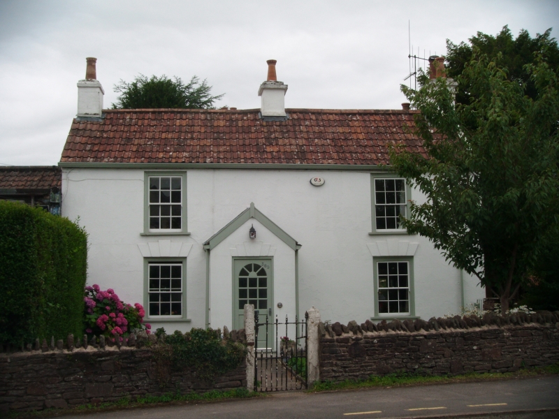
ST 68 SE FRAMPTON COTTERELL C.P. CHURCH ROAD
(south side)
3/8 No. 369
G.V. II
House. Early C19. Render, lined-out, double roman tile roof. 2 storeys,
2 windows, all sashes, those below have stepped voussoirs and keystone, off-centre
half-glazed door, central and end stacks.
Listing NGR: ST6636182018
External links are from the relevant listing authority and, where applicable, Wikidata. Wikidata IDs may be related buildings as well as this specific building. If you want to add or update a link, you will need to do so by editing the Wikidata entry.


Other nearby listed buildings
