Approximate Location Map
Large Map »
Latitude: 51.5427 / 51°32'33"N
Longitude: -2.2835 / 2°17'0"W
OS Eastings: 380433
OS Northings: 182678
OS Grid: ST804826
Mapcode National: GBR 0NN.CGG
Mapcode Global: VH95W.CHN7
Plus Code: 9C3VGPV8+3H
Entry Name: The Almshouse and Former School and Boundary Walls and Gate Piers to the Road
Listing Date: 3 March 1961
Grade: II*
Source: Historic England
Source ID: 1129328
English Heritage Legacy ID: 34261
ID on this website: 101129328
Location: Badminton, South Gloucestershire, GL9
County: South Gloucestershire
Civil Parish: Badminton
Built-Up Area: Badminton
Traditional County: Gloucestershire
Lieutenancy Area (Ceremonial County): Gloucestershire
Church of England Parish: Badminton St Michael and All Angels
Church of England Diocese: Gloucester
Tagged with: Almshouse
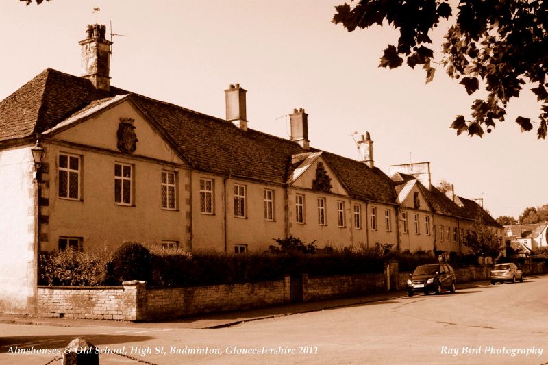
BADMINTON C.P. HIGH STREET (south side)
ST 8082
12/51 The Almshouses and former School
3.3.61 and Boundary Walls and
G.V. Gate piers to the road
II*
Row of 7 almshouses, now 4 almshouses and a disused school. Circa 1707-09 built
by Thomas Hayward of Badminton, for Mary, first Duchess of Beaufort. Rendered
with freestone quoins; hipped Cotswold stone slate roof; ashlar stacks with
cornice; coved eaves cornice. Queen Anne style. 2 storeys. 3:3:3:3:3 bays;
the outer and central parts are slightly advanced and are surmounted by coped
pediments which bear the Beaufort arms in the tympanum (full armorial bearings
with crests and supporters to the centre, diamond shield in elaborate cartouche
under a coronet to the ends). 2-light cross windows with diamond pattern lead
glazing. Plain square headed door openings between each window; panelled doors
with upper 2-lights glazed with diamond pattern lead cames; central door has
ashlar bolection moulded surround. Low, coped coursed squared rubble boundary
walls; central ashlar gatepiers with ball finials.
Listing NGR: ST8042582677
External links are from the relevant listing authority and, where applicable, Wikidata. Wikidata IDs may be related buildings as well as this specific building. If you want to add or update a link, you will need to do so by editing the Wikidata entry.


Other nearby listed buildings
