Approximate Location Map
Large Map »
Latitude: 51.436 / 51°26'9"N
Longitude: -2.8564 / 2°51'22"W
OS Eastings: 340569
OS Northings: 171124
OS Grid: ST405711
Mapcode National: GBR JC.NQ7N
Mapcode Global: VH7C7.F5TH
Plus Code: 9C3VC4PV+9F
Entry Name: Coleridge Cottage
Listing Date: 5 April 1952
Grade: II
Source: Historic England
Source ID: 1129725
English Heritage Legacy ID: 33108
ID on this website: 101129725
Location: Clevedon, North Somerset, BS21
County: North Somerset
Civil Parish: Clevedon
Built-Up Area: Clevedon
Traditional County: Somerset
Lieutenancy Area (Ceremonial County): Somerset
Tagged with: Cottage
OLD CHURCH ROAD
1.
5121
(North Side)
No 55 (Coleridge Cottage)
and No 57
ST 4071 1/9 5.4.52.
II
2.
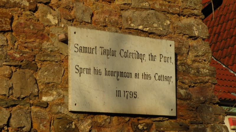
2 storey rubble cottages, whitewashed to left. Pantile roof. 2 casement windows
to each cottage. No 55 has brick porch with pitched wooden roof and plaque inscribed:
"Samuel Taylor Coleridge the poet spent his honeymoon in this cottage 1795".
No 57 has lean-to extension to left.
Listing NGR: ST4056971124
External links are from the relevant listing authority and, where applicable, Wikidata. Wikidata IDs may be related buildings as well as this specific building. If you want to add or update a link, you will need to do so by editing the Wikidata entry.


Other nearby listed buildings
