Approximate Location Map
Large Map »
Latitude: 53.1628 / 53°9'46"N
Longitude: -2.2125 / 2°12'45"W
OS Eastings: 385886
OS Northings: 362879
OS Grid: SJ858628
Mapcode National: GBR 12B.RFX
Mapcode Global: WHBC0.ZRKN
Plus Code: 9C5V5Q7P+4X
Entry Name: 52, High Street
Listing Date: 4 April 1975
Grade: II
Source: Historic England
Source ID: 1130503
English Heritage Legacy ID: 55885
ID on this website: 101130503
Location: Congleton, Cheshire East, Cheshire, CW12
County: Cheshire East
Civil Parish: Congleton
Built-Up Area: Congleton
Traditional County: Cheshire
Lieutenancy Area (Ceremonial County): Cheshire
Church of England Parish: Congleton Team
Church of England Diocese: Chester
l.
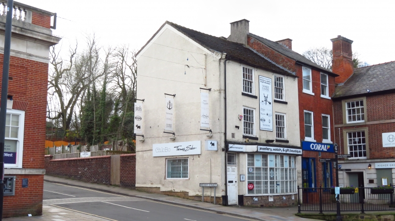
5144 HIGH STREET
(South Side)
No 52
SJ 8562 1/94
II
2.
C18, the core probably earlier. Modern roughcast; 3 storeys; 2 sash windows
in broad frames; plain eaves; old stone slates, Modern shop fronts.
Listing NGR: SJ8588662879
External links are from the relevant listing authority and, where applicable, Wikidata. Wikidata IDs may be related buildings as well as this specific building. If you want to add or update a link, you will need to do so by editing the Wikidata entry.


Other nearby listed buildings
