Approximate Location Map
Large Map »
Latitude: 52.2444 / 52°14'39"N
Longitude: 0.7128 / 0°42'45"E
OS Eastings: 585301
OS Northings: 264153
OS Grid: TL853641
Mapcode National: GBR QF0.71H
Mapcode Global: VHKD4.9VNB
Plus Code: 9F426PV7+P4
Entry Name: 89, Whiting Street
Listing Date: 12 July 1972
Grade: II
Source: Historic England
Source ID: 1132609
English Heritage Legacy ID: 467866
ID on this website: 101132609
Location: Bury St Edmunds, West Suffolk, IP33
County: Suffolk
District: West Suffolk
Civil Parish: Bury St Edmunds
Built-Up Area: Bury St Edmunds
Traditional County: Suffolk
Lieutenancy Area (Ceremonial County): Suffolk
Church of England Parish: Bury St Edmunds St Mary
Church of England Diocese: St.Edmundsbury and Ipswich
Tagged with: Building
BURY ST EDMUNDS
TL8564SW WHITING STREET
639-1/14/733 (West side)
12/07/72 No.89
GV II
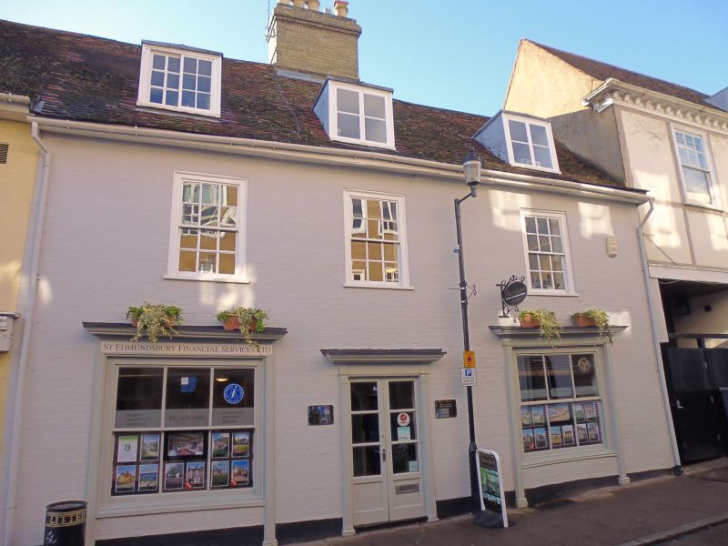
House, now offices. C17 and early C19. Timber-framed core;
brick front, now painted. Plaintiled roof.
EXTERIOR: 2 storeys, cellar and attics; front in 3-and-a-half
bays with a large internal chimney-stack. 3 window range:
12-pane sashes in flush cased frames. 2 early C19 shop windows
to ground storey with glazing-bars, plain pilasters and
cornices. 3 flat-headed dormers, 2 with 2-light single bar
casements, one on left with a small-paned sliding sash window.
A C20 glazed central door with an early C19 doorcase has
narrow reeded pilasters and a shallow cornice.
INTERIOR: cellar, below the right half of the front, with
walls of flint rubble and brick, rendered, has a heavy
supporting timber ceiling with joists set flat. This has been
used as a bakehouse/brewhouse and has a large timber lintel to
a former fireplace, partly infilled by a later copper, etc.
On the ground storey the stack has been tunnelled through to
give access to the rear. To the left of the entry is a
fragment of timber partition wall; the remaining timbers are
concealed or boxed in.
On the 1st storey, the remains of a large timber lintel on the
right side of the stack and 2 boxed-in main beams not related
to the position of the stack. To the left of the stack the
floor level is lower, with main posts and a tie-beam exposed.
Roof timbers all covered.
Listing NGR: TL8530164153
External links are from the relevant listing authority and, where applicable, Wikidata. Wikidata IDs may be related buildings as well as this specific building. If you want to add or update a link, you will need to do so by editing the Wikidata entry.


Other nearby listed buildings
