Approximate Location Map
Large Map »
Latitude: 53.719 / 53°43'8"N
Longitude: -2.1022 / 2°6'7"W
OS Eastings: 393353
OS Northings: 424737
OS Grid: SD933247
Mapcode National: GBR FTRF.PK
Mapcode Global: WHB8C.PS59
Plus Code: 9C5VPV9X+J4
Entry Name: 106-116, Burnley Road
Listing Date: 22 February 1984
Grade: II
Source: Historic England
Source ID: 1133756
English Heritage Legacy ID: 339048
ID on this website: 101133756
Location: Hole Bottom, Calderdale, West Yorkshire, OL14
County: Calderdale
Civil Parish: Todmorden
Built-Up Area: Todmorden
Traditional County: Yorkshire
Lieutenancy Area (Ceremonial County): West Yorkshire
Church of England Parish: Todmorden St Mary
Church of England Diocese: Leeds
Tagged with: Building
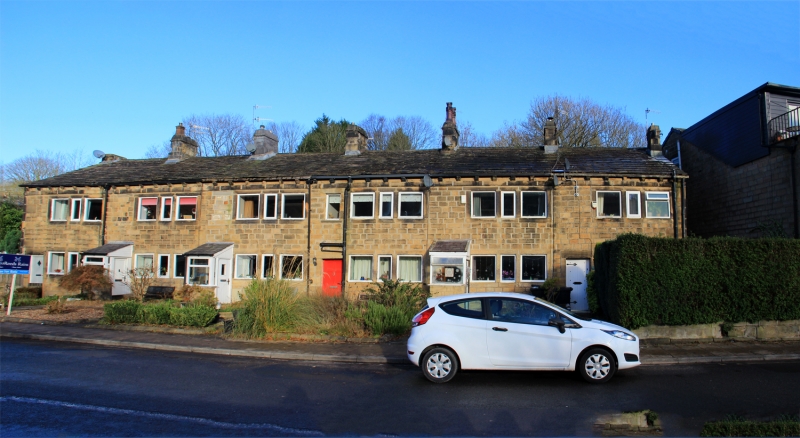
SD 9324 TODMORDEN (former M.B.) BURNLEY ROAD
(north side)
6/64 Nos. 106 to 116 (even)
II
Row of 6 cottages. Early C19. Watershot masonry, stone slate roof. Quoins.
2 storeys. 6 bays. Each bay has doorway with sill ties and flat faced
mullioned windows of 3 lights to each floor. Gutter bracket, 7 stacks to ridge.
Listing NGR: SD9335324737
External links are from the relevant listing authority and, where applicable, Wikidata. Wikidata IDs may be related buildings as well as this specific building. If you want to add or update a link, you will need to do so by editing the Wikidata entry.


Other nearby listed buildings
