Approximate Location Map
Large Map »
Latitude: 53.6905 / 53°41'25"N
Longitude: -1.7926 / 1°47'33"W
OS Eastings: 413795
OS Northings: 421578
OS Grid: SE137215
Mapcode National: GBR HTXR.QS
Mapcode Global: WHC9V.FHMN
Plus Code: 9C5WM6R4+5X
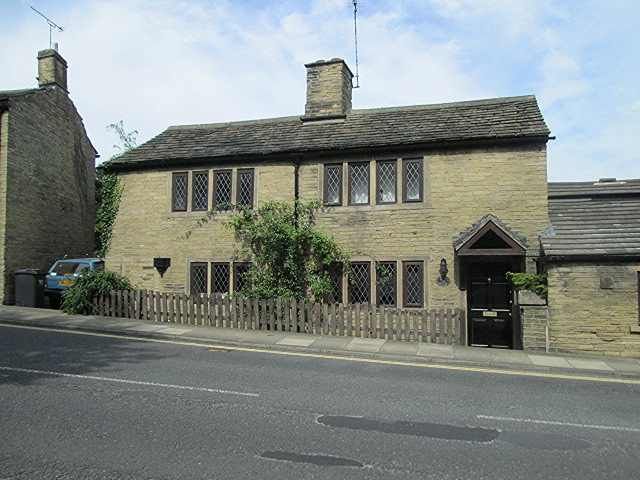
Entry Name: 6, Crowtrees Lane
Listing Date: 2 December 1983
Grade: II
Source: Historic England
Source ID: 1133831
English Heritage Legacy ID: 338820
ID on this website: 101133831
Location: Rastrick, Calderdale, West Yorkshire, HD6
County: Calderdale
Electoral Ward/Division: Rastrick
Parish: Non Civil Parish
Built-Up Area: Brighouse
Traditional County: Yorkshire
Lieutenancy Area (Ceremonial County): West Yorkshire
Church of England Parish: Rastrick St Matthew
Church of England Diocese: Leeds
Tagged with: Building
BRIGHOUSE CROWTREES LANE
SE 12 SW (west side)
3/77 No. 6
G. V.
II
A pair of cottages now one. Early C19. Hammer-dressed stone, stone slate roof.
Front to main street has 2 doorways with monolithic jambs (one solid), and thin
flat faced mullioned windows of 3 lights and 4 lights with two 4-light windows
over. Central stack to ridge.
Listing NGR: SE1379521578
External links are from the relevant listing authority and, where applicable, Wikidata. Wikidata IDs may be related buildings as well as this specific building. If you want to add or update a link, you will need to do so by editing the Wikidata entry.


Other nearby listed buildings
