Approximate Location Map
Large Map »
Latitude: 53.6432 / 53°38'35"N
Longitude: -1.7742 / 1°46'27"W
OS Eastings: 415025
OS Northings: 416321
OS Grid: SE150163
Mapcode National: GBR JV19.PR
Mapcode Global: WHCB1.QPBF
Plus Code: 9C5WJ6VG+78
Entry Name: The Fly Boat Public House
Listing Date: 29 September 1978
Grade: II
Source: Historic England
Source ID: 1134292
English Heritage Legacy ID: 339716
ID on this website: 101134292
Location: Aspley, Kirklees, West Yorkshire, HD1
County: Kirklees
Electoral Ward/Division: Newsome
Parish: Non Civil Parish
Built-Up Area: Huddersfield
Traditional County: Yorkshire
Lieutenancy Area (Ceremonial County): West Yorkshire
Church of England Parish: Huddersfield St Peter
Church of England Diocese: Leeds
Tagged with: Pub
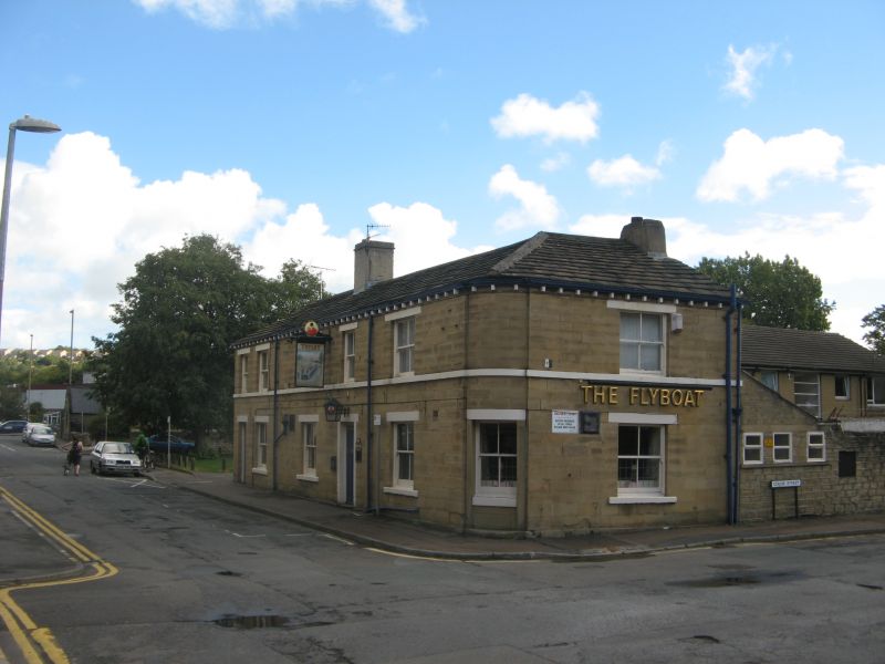
COLNE STREET
1.
5113 (East Side)
The Fly Boat
Public House
SE 1516 34/385
II
2.
Mid C19. Ashlar. Hipped stone slate roof. 2 storeys. Continuous 1st floor
sill. Rounded corner. 5 ranges of sashes to west side, one to south side.
2 doors, one with 4 fielded panels.
Listing NGR: SE1502516321
External links are from the relevant listing authority and, where applicable, Wikidata. Wikidata IDs may be related buildings as well as this specific building. If you want to add or update a link, you will need to do so by editing the Wikidata entry.


Other nearby listed buildings
