Approximate Location Map
Large Map »
Latitude: 53.6042 / 53°36'15"N
Longitude: -1.7122 / 1°42'43"W
OS Eastings: 419144
OS Northings: 412001
OS Grid: SE191120
Mapcode National: GBR JVHR.3Q
Mapcode Global: WHCB8.NNWS
Plus Code: 9C5WJ73Q+M4
Entry Name: Boundary Stone 150 Yards South of Junction with Riley Lane
Listing Date: 16 May 1984
Grade: II
Source: Historic England
Source ID: 1135335
English Heritage Legacy ID: 341197
ID on this website: 101135335
Location: Causeway Foot, Kirklees, West Yorkshire, HD8
County: Kirklees
Civil Parish: Kirkburton
Traditional County: Yorkshire
Lieutenancy Area (Ceremonial County): West Yorkshire
Church of England Parish: Shelley Emmanuel
Church of England Diocese: Leeds
Tagged with: Boundary marker
SE 11 SE PENISTONE ROAD
SE 1914 1200 (west side)
Kirkburton
5/82 Boundary stone 150 yards
south of junction with
Riley Lane
II
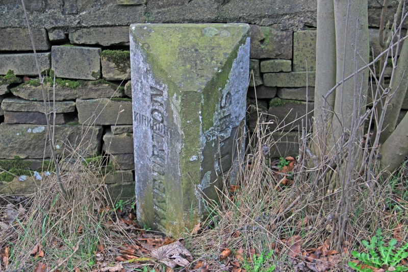
Boundary stone. Mid or late C19. Triangular stone post. Inscribed
on 2 faces. KIRKBURTON SHELLEY
The same words are superimposed in larger, later lettering reading
vertically.
Listing NGR: SE1914412001
External links are from the relevant listing authority and, where applicable, Wikidata. Wikidata IDs may be related buildings as well as this specific building. If you want to add or update a link, you will need to do so by editing the Wikidata entry.


Other nearby listed buildings
