Approximate Location Map
Large Map »
Latitude: 53.6915 / 53°41'29"N
Longitude: -1.3131 / 1°18'47"W
OS Eastings: 445454
OS Northings: 421896
OS Grid: SE454218
Mapcode National: GBR MT8R.HF
Mapcode Global: WHDC6.SGWV
Plus Code: 9C5WMMRP+JP
Entry Name: The Malt Shovel Public House
Listing Date: 29 July 1950
Last Amended: 15 November 1988
Grade: II*
Source: Historic England
Source ID: 1135451
English Heritage Legacy ID: 342655
ID on this website: 101135451
Location: Pontefract, Wakefield, West Yorkshire, WF8
County: Wakefield
Electoral Ward/Division: Pontefract North
Parish: Non Civil Parish
Built-Up Area: Pontefract
Traditional County: Yorkshire
Lieutenancy Area (Ceremonial County): West Yorkshire
Church of England Parish: Pontefract St Giles with St Mary
Church of England Diocese: Leeds
Tagged with: Pub
PONTEFRACT CORN MARKET
SE 4521 NW
(south-west side)
7/16
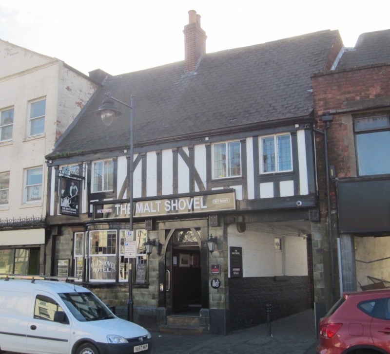
No 1 (The Malt Shovel
29.7.50 Public House) (formerly
listed under Best Fair)
GV II+
Public house on site of older building. C14 cellar with late C19 public house above
altered in C20. 2 storeys and cellar, 4 first-floor windows. Public house: red
brick, faced with glazed tiles on ground floor and timber-framing on first floor;
Welsh slate roof. Ground floor; to right, wide passage opening through to rear; to
left segmental tripartite bow window and part-glazed door below overlight. First
floor: studding with central braces, interrupted by paired casement windows.
Windows and door have leaded glazing. Brick ridge stack to left of door. Interior,
cellar under front of building: two bays of sexpartite rib vaulting, the ashlar ribs
heavy and deeply chamfered, and running out into side walls, with a circular boss in
each bay, the northern one damaged, the southern one with fine face mask; ashlar
door suround has chamfered shouldered lintel, and is rebated for outward-opening
door. A flagged barrel-vaulted passage curves as it climbs up to stone steps at
rear of front range; bar has imported chamfered beams. The March 1968 Provisional
List compares the cellar with one in Malton and a finer one in Gloucester. Recorded
by West Yorkshire Archaeology Unit.
Listing NGR: SE4545421895
External links are from the relevant listing authority and, where applicable, Wikidata. Wikidata IDs may be related buildings as well as this specific building. If you want to add or update a link, you will need to do so by editing the Wikidata entry.


Other nearby listed buildings
