Approximate Location Map
Large Map »
Latitude: 51.5064 / 51°30'23"N
Longitude: -1.5331 / 1°31'59"W
OS Eastings: 432502
OS Northings: 178714
OS Grid: SU325787
Mapcode National: GBR 6Z0.H76
Mapcode Global: VHC1D.CDWJ
Plus Code: 9C3WGF48+HQ
Entry Name: 35, High Street
Listing Date: 11 July 1983
Grade: II
Source: Historic England
Source ID: 1136219
English Heritage Legacy ID: 39415
ID on this website: 101136219
Location: Lambourn, West Berkshire, RG17
County: West Berkshire
Civil Parish: Lambourn
Built-Up Area: Lambourn
Traditional County: Berkshire
Lieutenancy Area (Ceremonial County): Berkshire
Church of England Parish: Lambourn
Church of England Diocese: Oxford
Tagged with: Building
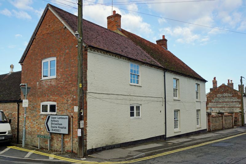
SU 3278 LAMBOURN HIGH STREET
(west side)
4/1 No 35
GV II
House. Early C19. Two storeys painted brick. Dentil eaves, old tile roof. Lower
wing to left. 1 vertical sliding sash on first floor, 1, 4 pane fixed light on
ground floor, right wing has flanking chimneys. 2 vertical sliding sash windows
with glazing bars, in reveals. Former central door opening now blocked.
Listing NGR: SU3250278714
External links are from the relevant listing authority and, where applicable, Wikidata. Wikidata IDs may be related buildings as well as this specific building. If you want to add or update a link, you will need to do so by editing the Wikidata entry.


Other nearby listed buildings
