Approximate Location Map
Large Map »
Latitude: 50.2143 / 50°12'51"N
Longitude: -5.4804 / 5°28'49"W
OS Eastings: 151795
OS Northings: 40721
OS Grid: SW517407
Mapcode National: GBR DXV3.NH2
Mapcode Global: VH12D.YWL2
Plus Code: 9C2P6G79+PR
Entry Name: 46, Fore Street
Listing Date: 22 December 1972
Grade: II
Source: Historic England
Source ID: 1136817
English Heritage Legacy ID: 68999
ID on this website: 101136817
Location: St Ives, Cornwall, TR26
County: Cornwall
Civil Parish: St. Ives
Built-Up Area: St Ives
Traditional County: Cornwall
Lieutenancy Area (Ceremonial County): Cornwall
Church of England Parish: St Ives
Church of England Diocese: Truro
Tagged with: Building
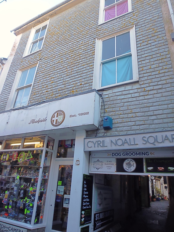
FORE STREET
1. (West side)
1587 -----------
No 46
SW 54 SW 1/79
II GV
2.
Early Cl9. Slate hung front, Three storeys. Two windows, sashes in
moulded cases, windows on top floor are modern. Modern shop front with
large incongruous fascia. Carriageway on right. Slate roof. Group value.
Nos 42 to 52 (even) form a group.
Listing NGR: SW5179540721
External links are from the relevant listing authority and, where applicable, Wikidata. Wikidata IDs may be related buildings as well as this specific building. If you want to add or update a link, you will need to do so by editing the Wikidata entry.


Other nearby listed buildings
