Approximate Location Map
Large Map »
Latitude: 52.9373 / 52°56'14"N
Longitude: -1.3095 / 1°18'34"W
OS Eastings: 446507
OS Northings: 337986
OS Grid: SK465379
Mapcode National: GBR 7G6.ZQB
Mapcode Global: WHDGW.VFMK
Plus Code: 9C4WWMPR+W6
Entry Name: Village Cross
Listing Date: 10 November 1967
Grade: II
Source: Historic England
Source ID: 1140421
English Heritage Legacy ID: 352305
ID on this website: 101140421
Location: Stanton-by-Dale, Erewash, Derbyshire, DE7
County: Derbyshire
District: Erewash
Civil Parish: Stanton by Dale
Built-Up Area: Stanton-by-Dale
Traditional County: Derbyshire
Lieutenancy Area (Ceremonial County): Derbyshire
Church of England Parish: Stanton-by-Dale St Michael and All Angels
Church of England Diocese: Derby
Tagged with: High cross
PARISH OF STANTON BY DALE STANHOPE STREET
SK 43 NE
6/102 (West Side)
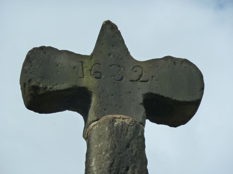
Village Cross
10.11.67 II
Village cross. Medieval and 1632. Gritstone. Square plinth
approximately 3 feet high, surmounted by two steps and a
pyramidal upper part. Square cross base and plain shaft. Cross
top dated 1632.
Listing NGR: SK4650737986
External links are from the relevant listing authority and, where applicable, Wikidata. Wikidata IDs may be related buildings as well as this specific building. If you want to add or update a link, you will need to do so by editing the Wikidata entry.


Other nearby listed buildings
