Approximate Location Map
Large Map »
Latitude: 52.2411 / 52°14'27"N
Longitude: 0.7137 / 0°42'49"E
OS Eastings: 585382
OS Northings: 263790
OS Grid: TL853637
Mapcode National: GBR QF0.F97
Mapcode Global: VHKD4.BX5W
Plus Code: 9F426PR7+CF
Entry Name: 53 and 54, Westgate Street
Listing Date: 12 July 1972
Grade: II
Source: Historic England
Source ID: 1142324
English Heritage Legacy ID: 467688
ID on this website: 101142324
Location: Bury St Edmunds, West Suffolk, IP33
County: Suffolk
District: West Suffolk
Civil Parish: Bury St Edmunds
Built-Up Area: Bury St Edmunds
Traditional County: Suffolk
Lieutenancy Area (Ceremonial County): Suffolk
Church of England Parish: Bury St Edmunds St Mary
Church of England Diocese: St.Edmundsbury and Ipswich
Tagged with: Building
BURY ST EDMUNDS
TL8563NW WESTGATE STREET
639-1/15/677 (North side)
12/07/72 Nos.53 AND 54
GV II
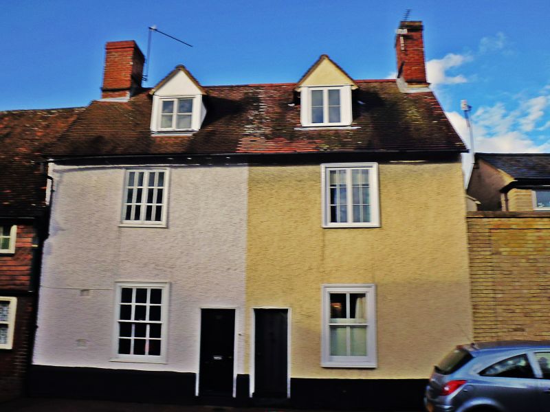
A pair of cottages. C18, extended in the early C19.
Timber-framed; red brick to lower wall of east gable;
roughcast rendered; plaintiled roof; gable and chimney-stacks.
EXTERIOR: 2 storeys and attics; gable end chimney-stacks. 2
window range: small-paned 2-light casements to the 1st storey
and sashes to the ground storey, No.53 12-pane, No.54 with
plain glass, both in flush cased frames. 2 gabled dormers with
2-light single bar casement windows. 2 central entrance doors,
boarded. The 2-storey rear extension has a lean-to roof which
runs into the slope of the main roof.
INTERIOR: no cellars. The 2 cottages have a matching layout,
initially with a single living-room in the front and a walk-in
larder and corner stair behind. The C19 extension enlarged the
larder area into a room and the original rear wall was
removed. The infill between the studding of the partition wall
has now been removed in each cottage to make one larger room.
The red brick chimney-stacks each have reinstated open hearths
with timber lintels, in No.54 with a marked camber. Many
re-used timbers in both cottages and very light framing. Newel
stair beside each stack. On the west, No.53 is butted up
against the adjoining house and has a section of plastered
external wall with comb-pargeting backing on the stair.
All roof timbers covered: the original roof of No.54 was
destroyed by fire in 1982.
Listing NGR: TL8538263790
External links are from the relevant listing authority and, where applicable, Wikidata. Wikidata IDs may be related buildings as well as this specific building. If you want to add or update a link, you will need to do so by editing the Wikidata entry.


Other nearby listed buildings
