Approximate Location Map
Large Map »
Latitude: 50.2324 / 50°13'56"N
Longitude: -5.2283 / 5°13'42"W
OS Eastings: 169862
OS Northings: 41916
OS Grid: SW698419
Mapcode National: GBR Z3.DHPB
Mapcode Global: VH12K.BFB7
Plus Code: 9C2P6QJC+WM
Entry Name: 3 and 4 Station Hill
Listing Date: 1 December 1951
Grade: II
Source: Historic England
Source ID: 1142568
English Heritage Legacy ID: 66862
ID on this website: 101142568
Location: Redruth, Cornwall, TR15
County: Cornwall
Civil Parish: Redruth
Built-Up Area: Redruth
Traditional County: Cornwall
Lieutenancy Area (Ceremonial County): Cornwall
Church of England Parish: Redruth
Church of England Diocese: Truro
Tagged with: Building
This list entry was subject to a Minor Amendment on 18 July 2022 to update the name address and text and reformat the text to current standards
SW 64 SE
11/300
REDRUTH
STATION HILL (north side)
Nos.3 and 4
1.12.51
GV
II
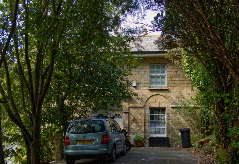
Pair of houses. Early C19, slightly altered. Coursed squared granite at the front, uncoursed rubble sides and rear, with quoins; slate roof. Rectangular double-depth plan, each house single-fronted. Two storeys and three bays over a basement, on a site which slopes down from right to left so that the basement of No.3 is exposed; symmetrical, in classical style; in the centre, a shallow recessed porch with ashlar architrave in the form of a semi-elliptical arch with imposts, keystone, and cornice, containing coupled doorways with reeded surrounds under a single fanlight which is no longer glazed but has remains of geometrical glazing bars. The ground floor has two sashed windows set in round- headed recesses with run-out imposts (but the head of that to the left now covered by a name board), both windows 12-paned except that the lower leaf of that to the right now lacks glazing bars; the first floor has three 16-pane sashes; all windows have flat-arched heads with keystones. Projecting eaves, and hipped roof of shallow pitch with chimneys behind the ridge. No.3 to the left has a basement expressed as a plinth, of large ashlar blocks, with a 12-pane sashed window; and the narrow gap between Nos.2 and 3 is filled by a two-storey screen wall with a door at basement level and a blind window above. Rear: two round- headed stair windows with Y-tracery, 12-pane sashes to the principal floors, a 16-pane sash to the basement of No.3, and back doors on two levels.
Listing NGR: SW6986241916
External links are from the relevant listing authority and, where applicable, Wikidata. Wikidata IDs may be related buildings as well as this specific building. If you want to add or update a link, you will need to do so by editing the Wikidata entry.


Other nearby listed buildings
